To assist users with uploading instrumentation data and project lab fee information, a variety of example Link Mapping Project Template files (.link) are provided with EQuIS Geotech:
•CPT Dissipation – Hogentogler
The files are available for download in the Products\Geotechnical folder on the Downloads Dashboard on the EarthSoft Community Center.
Except for the Project_LabTestFees file, these example Link Mapping Project Template files are based on the Geotechnical_v2 format and all the files are designed to be used as a "virtual" format (see the Installation and Configuration articles for setup details). Once the Link Mapping Project Template files are appropriately setup as virtual formats, they can be used to upload electronic data deliverables (EDDs) to EQuIS via the Enterprise EDP EDD Upload widget.
Warning: To upload a file in the EDP EDD Upload Widget, please do not use the following characters in the uploaded file as the system will not appropriately interpret the file path: . : * ? " < > | \ /
See the EDD Package Naming Convention article for more information. |
CPT – Geotech AB
The CPT_Geotech_AB.link Link Mapping Project file uses the Geotechnical_v2 format to map Cone Penetration Test (CPT) data (in the Geotech AB .cpt file format) to the DT_LOCATION, DT_LOCATION_PARAMETER and DT_DOWNHOLE_POINT_DATA tables.
The following parameters are imported to the DT_DOWNHOLE_POINT_DATA table:
•Depth
•Cone resistance (qt)
•Sleeve friction (fs)
•Pore pressure (u2)
•Push rate
•X tilt angle
•Y tilt angle
The test records are imported to the DT_DOWNHOLE_POINT_DATA table in metric units. The tip resistance values are imported as MPa, while the pore pressure and friction resistance are imported as KPa. The push rate values are calculated and imported as cm/s. The depth values are mapped to the DT_DOWNHOLE_POINT_DATA table in meters.
The CPT Probe ID is mapped to the DT_LOCATION_PARAMETER table.
The maximum tip advancement depth is converted to feet and stored in DT_LOCATION.TOTAL_DEPTH.
Note: If a corresponding location is not present in the database, this Link project will create one with the location type = ‘CPT’. |
|---|
CPT – Hogentogler
The Hogentogler file (.cpt) produces tip resistance, friction resistance, and pore pressure readings in KPa. The CPT_Hogentogler.link Link Mapping Project file uses the Geotechnical_v2 format to map CPT data to the DT_LOCATION, DT_LOCATION_PARAMETER and DT_DOWNHOLE_POINT_DATA tables.
The following parameters are imported to the DT_DOWNHOLE_POINT_DATA table:
•Depth
•Cone resistance (qt)
•Sleeve friction (fs)
•Pore pressure (u2)
•Push rate
•X tilt angle
•Y tilt angle
The test records are imported to the DT_DOWNHOLE_POINT_DATA table in metric units. The tip resistance values are imported as MPa, while the pore pressure and friction resistance are imported as KPa. The push rate values are imported as cm/s. The depth values are mapped to the DT_DOWNHOLE_POINT_DATA table in meters.
The CPT Probe ID is mapped to the DT_LOCATION_PARAMETER table.
The maximum tip advancement depth is converted to feet and stored in DT_LOCATION.TOTAL_DEPTH.
Note: If a corresponding location is not present in the database, this Link project will create one with the location type = ‘CPT’. |
|---|
CPT Dissipation – GeoTac
The CPT_DIS_Geotech_AB.link Link Mapping Project file imports CPT Dissipation data in the GeoTac file format to the database. The file uses the Geotechnical_v2 format to map dissipation data to the DT_GEO_TEST, DT_GEO_RESULT, and DT_GEO_TEST_PARAMETER tables. The following parameters are mapped to the database:
•Test Depth
•Elapsed Time
•Pore Pressure
The test depth is imported as meters. The pore pressure values are imported as ‘KPa’. The elapsed time values are imported as seconds.
Note: The CPT_DIS_Geotech_AB.link Link Mapping Project file imports elapsed time with a unit of "s". This can be changed in the Link Mapping Project file to be any format of seconds (e.g., "sec", "seconds") to match the reference value in the database. |
|---|
Note: If a corresponding location is not present in the database, this Link project will create one with the location type = ‘CPT’. |
|---|
CPT Dissipation – Hogentogler
The CPT_DIS_Hogentogler.link Link Mapping Project file imports CPT Dissipation data in the Hogentogler file format to the database. The file uses the Geotechnical_v2 format to map dissipation data to the DT_GEO_TEST, DT_GEO_RESULT, and DT_GEO_TEST_PARAMETER tables. The following parameters are mapped to the database:
•Test Depth
•Elapsed Time
•Pore Pressure
The test depth is imported as meters. The pore pressure values are imported as ‘KPa’. The elapsed time values are imported as seconds.
Note: The CPT_DIS_Hogentogler.link Link Mapping Project file imports elapsed time with a unit of "s". This can be changed in the Link Mapping Project file to be any format of seconds (e.g., "sec", "seconds") to match the reference value in the database. |
|---|
This Link project supports a maximum of 10 different dissipation tests per loaded file.
Note: If a corresponding location is not present in the database, this Link project will create one with the location type = ‘CPT’. |
|---|
DMT – EarthSoft Standard File
The DMT_EarthSoft.link Mapping Project file imports DMT data from an EarthSoft defined standard file structure (ES_DMT_Standard_Input.xlsx file, which is available in the Products\Geotechnical folder on the Downloads Dashboard on the ECC). The Link file uses the Geotechnical_v2 format to map dissipation data to the DT_LOCATION, DT_LOCATION_PARAMETER, DT_WATER_TABLE, and DT_DOWNHOLE_POINT_DATA tables. The “Project #:” value in the file must equal the FACILITY_CODE.
The initial, final, and average ΔA, ΔB, and Zm values are mapped to the DT_LOCATION_PARAMETER table in bar units.
The A, B, and C values are mapped to the DT_DOWNHOLE_POINT_DATA table in bar units. The Link project stops importing data when there are null values. The depth values are imported in meters.
The water depth is mapped to the DT_WATER_TABLE table with the DT_WATER_TABLE.TYPE = ‘DMT’. The depth is imported in units defined in cell G5 of the ES_DMT_Standard_Input file.
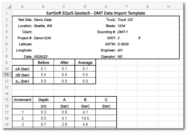
The maximum blade advancement depth is stored in DT_LOCATION.TOTAL_DEPTH in feet units.
Note: If a corresponding location is not present in the database, this Link project will create one with the location type = ‘DMT’. |
|---|
Project Lab Test Fee Override
The Project_LabTestFees.link Link Mapping Project file imports a Lab Test Project override fee value for a Lab Test method from an EarthSoft defined standard file structure (ES_Project_LabTestFees.xlsx file, which is available in the Products\Geotechnical folder on the Downloads Dashboard on the ECC). This Link Mapping File uses the Geo_Lab_Fees format to map the fee override values to the DT_COST table with the DT_COST.COST_TYPE = ‘geolab_project_fees’.
The TEST_METHOD_CODE associated with the cost must be present in the RT_GEO_TEST_METHOD table.
Unconfined Compression – GeoTac
The UC_SIGMA1.link Link Mapping Project file imports the Unconfined Compression (UC) raw data from a GeoTac file in .trx format. The Link file uses the Geotechnical_v2 format to map the data to the DT_SAMPLE, DT_GEO_TEST and DT_GEO_RESULT tables.
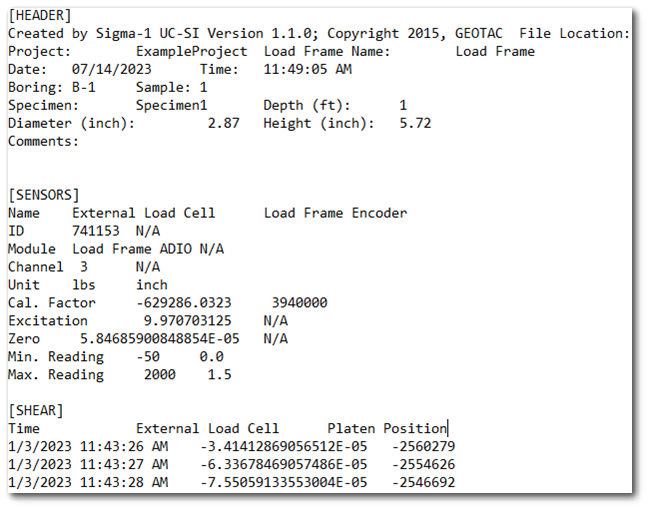
The sample must be present in the database prior to loading in the file. The “Project:” number in the file must equal the FACILITY_CODE.
The sample height and diameter values are mapped in inches.
Upon loading the data file into EDP, the raw data are converted from electrical units to engineering units by using the calibration factor, excitation value, and the zero value. The External Load Cell and Platen Position values are calibrated, converted, and mapped to the format as Load Reading and Deformation values.
Note: The UC_SIGMA1.link file only supports English units. |
|---|
Unconsolidated Undrained – GeoTac
The UU_SIGMA1.link Link Mapping Project file imports the Unconsolidated Undrained (UU) raw data from a GeoTac file in .trx format. The Link file uses the Geotechnical_v2 format to map the data to the DT_SAMPLE, DT_GEO_TEST and DT_GEO_RESULT tables.
The sample must be present in the database prior to loading in the file. The “Project:” number in the file must equal the FACILITY_CODE.
The sample height and diameter values are mapped in inches. The piston correction value is mapped in pounds.
Upon loading the data file into EDP, the raw data are converted from electrical units to engineering units by using the calibration factor, excitation value, and the zero value. The External Load Cell, Cell Pressure, and Platen Position values are calibrated, converted, and mapped to the format as Load Reading, Cell Pressure, and Deformation values.
Note: The UU_SIGMA1.link file only supports English units. |
|---|