EQuIS Geotech is integrated with EQuIS Collect for entering geotechnical field data on the standard EQuIS Geotech dashboards using Collect templates to generate data forms in the Web Forms widget. The Geotechnical Field Data Entry Template provides users with the ability to submit data collected in the field. Some of the forms provided by this template include borehole, sample, lithology, and CPT/DMT information. A unique data set is configured for each form to support Form Refresh functionality in the Web Forms.
This template only supports one TASK_CODE per facility.
Note: Since the Geotechnical Field Data Entry template is built on the Geotechnical_v2 format, the Geotechnical_v2 format must be available on the Enterprise site prior to uploading the template. |
|---|
See the Collect Enterprise Template Designer Page chapter of the online help for general details about designing and configuring Collect templates.
Pre-population
The Geotechnical Field Data Entry Template is pre-populated using sections of the Geotechnical Collect Report. Refer to the Geotechnical Collect Report to review the field parameters included in this report. As part of the Collect template configuration process, pre-population was applied to the template. The pre-population report can be updated as needed for specific project requirements.
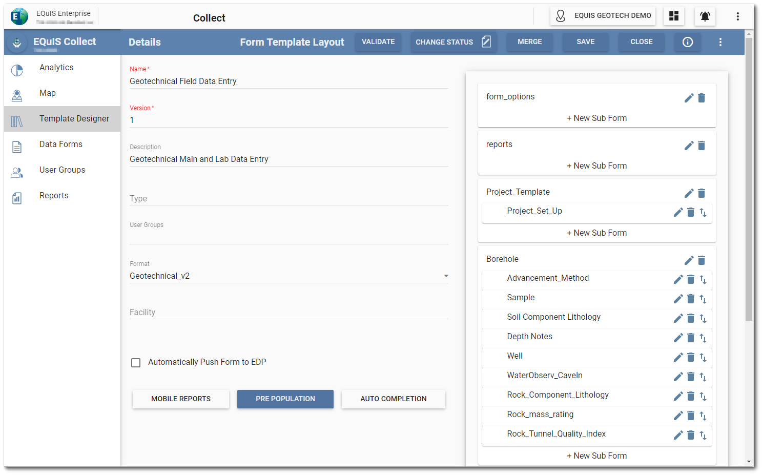
Template Layout
Collect templates can be viewed on the Template Designer page of the Collect Enterprise dashboard. The Preview ![]() icon displays the structure of the template and allows users to view any existing pre-population. Users can also select the Edit
icon displays the structure of the template and allows users to view any existing pre-population. Users can also select the Edit ![]() icon of unpublished templates to open the Form Template Layout window. The image below shows the Geotechnical Field Data Entry template open in the the Form Template Layout window.
icon of unpublished templates to open the Form Template Layout window. The image below shows the Geotechnical Field Data Entry template open in the the Form Template Layout window.
Project Form Setup
The following forms and subforms in the template provide for project information.
Form_Options:
•Purpose – Users must specify the form(s) they would like to submit to the database.
•Note that this form expects only one row.
Reports:
•Purpose – The form will filter the data displayed in the Collect report associated with the template. The purpose of this report is to provide a Data Preview of the output prior to data submittal.
•Note that this form expects only one row.
Project_Template:
•Purpose – The form displays the project related information (site address, project name, project reviewer, etc.).
•Note that this form expects only one row.
Project_Set_Up:
•Purpose – The Project_Set_Up form allows users to define various items, such as Boring Log/Subsurface Profile visibility options and reporting units for various geotechnical reports. The values defined in this form impact how the data are reported in the geotechnical output reports and EnviroInsite Boring Logs and Subsurface Profiles.
•Template is configured to pre-populate most of the data for this form through the Geotechnical Collect Report. The report does not pre-populate the Subsurface Profile visibility parameters.
•Note that this form expects only one row.
Field Data
The following forms and subforms in the template provide for capturing information relating to various field activities.
Borehole:
•Purpose – The Borehole form allows user to enter borehole information, including refusal, abandonment method, and coordinate information.
•Template is configured to pre-populate data for this form through the Geotechnical Collect Report.
Advancement_Method:
•Purpose – Users can define the method used to advance in the parent borehole.
•Template is configured to pre-populate data for this form through the Geotechnical Collect Report.
•This form is a child of the Borehole form.
Sample:
•Purpose – Users can use this form to enter sample information. They can also enter field sample test information here.
•Template is configured to pre-populate data for this form through the Geotechnical Collect Report.
•This form is a child of the Borehole form.
Soil Component Lithology:
•Purpose – Users can use this form to enter soil lithology information.
•Template is configured to pre-populate data for this form through the Geotechnical Collect Report.
•This form is a child of the Borehole form.
Depth Notes:
•Purpose – Users can use this form to enter depth specific notes.
•Template is configured to pre-populate data for this form through the Geotechnical Collect Report.
•This form is a child of the Borehole form.
Well:
•Purpose – Users can use this form to enter information about a well construction.
•It is suggested that the drop-down options for Segment Type and Material Type Code be updated in the template.
•This form is a child of the Borehole form.
WaterObserv_CaveIn:
•Purpose – Users can use this form to enter water observation or cave in information. Users can also specify if no water was encountered.
•Template is configured to pre-populate data for this form through the Geotechnical Collect Report.
•This form is a child of the Borehole form.
Rock_Component_Lithology:
•Purpose – Users can use this form to enter rock lithology information.
•Template is configured to pre-populate data for this form through the Geotechnical Collect Report.
•This form is a child of the Borehole form.
Rock_mass_rating:
•Purpose – Users can use this form to enter parameter values related to a Rock Mass Rating (RMR) system.
•Template is configured to prepopulate data for this form through the Geotechnical Collect Report.
•This form is a child of the Borehole form.
Rock_Tunnel_Quality_Index:
•Purpose – Users can use this form to parameter values related to a Tunnel Quality Index (Q) system.
•Template is configured to pre-populate data for this form through the Geotechnical Collect Report.
•This form is a child of the Borehole form.
CPT:
•Purpose – Users can use this form to enter the water depth (assumed or measured) for a CPT location.
•Template is configured to pre-populate data for this form through the Geotechnical Collect Report.
Dissipation Test:
•Purpose – Users can use this form to enter the water depth (assumed or measured) and/or the initial pore pressure value for a CPT Dissipation test.
•This form expects one record per Dissipation test depth.
•Template is configured to pre-populate data for this form through the Geotechnical Collect Report.
•This form is a child of the CPT form.
DMT:
•Purpose – Users can use this form to enter the water depth (assumed or measured) for a DMT location.
•Template is configured to pre-populate data for this form through the Geotechnical Collect Report.
Form Refresh Functionality
The Form Refresh functionality allows users to update an existing pre-populated data form with the most recent data stored in the database, without needing to create a new data form. Because the Geotechnical Field Data Entry Template is pre-populated, data forms created from the template can allow the form refresh functionality.
A unique data set is configured for each form to support Form Refresh functionality in the Web Forms.
Form |
Unique Data Set (Concatenation of) |
|---|---|
Form Options |
[facility code] |
Reports Filter |
[boring_id] |
Project_Template |
[facility code] |
Project_Set_Up |
[parent_facility_code] |
Borehole |
[location] |
Advancement_Method |
[location],'_|_',[start_depth] |
Sample |
[location],'_|_',[start_depth] |
Soil_Component_Lithology |
[parent_loc],'_|_',[Start_Depth] |
Rock_Component_Lithology |
[parent_loc],'_|_',[top_depth] |
Well_Data |
[parent_loc],'_|_',[Start_Depth],'_|_',[segment_type],'_|_',[material_type] |
WaterObserv_CaveIn |
[sys_loc_code],'_|_',[observation_depth],'_|_',[Observation_Type] |
Depth Notes |
[parent_loc],'_|_',[Start_Depth] |
Rock_Mass_Rating |
[parent_loc],'_|_',[top_depth] |
Rock_Tunnel_Quality_Index |
[parent_loc],'_|_',[depth] |
CPT |
[location] |
DMT |
[location] |
Dissipation Test |
[parent_loc],'_|_',[test_depth_original] |