EnviroInsite was originally developed around a simple database schema (i.e., EnviroInsite database). Data can be contained in either a Microsoft Access database file or Microsoft Excel spreadsheet. For many sites, Excel is adequate both with respect to the volume of data that can be stored (1,000,000 rows in the XLSX file) and the speed of data access. In some cases, it may be advantageous to use a database file format to make use of existing databases or for larger files where rapid data access is important.
The data is read as a relational database. Therefore, the well, screen and constituent names must be consistent in the different parts of the database file. For example, each Location in the Intervals worksheet must have at least one identical counterpart in the Locations worksheet. Likewise, each Location – Interval pair in the Observation table must have their counterpart in the Intervals table. The easiest way to start a new spreadsheet or database file is to find an existing file, like the ones contained in C:\Program Files\EarthSoft\EnviroInsite\Example\ (assuming the typical EnviroInsite installation path of C:\Program Files\EarthSoft\EnviroInsite).
View a training video on EnviroInsite Database fundamentals here.
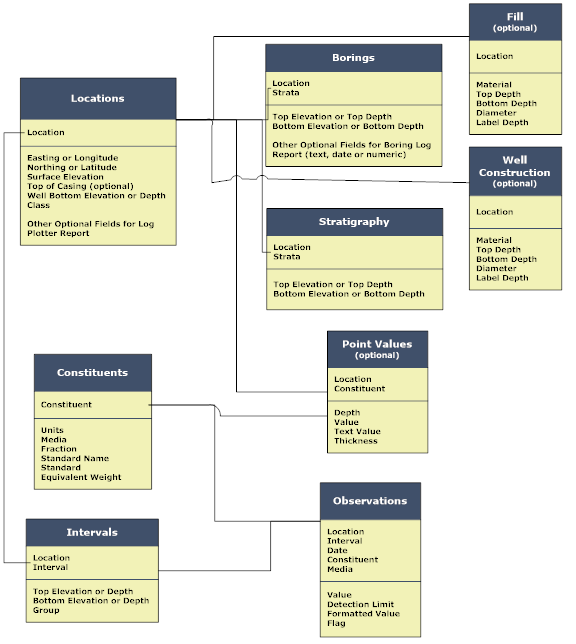
Data Tables Accessed by EnviroInsite
Table |
Fields |
|---|---|
Name, location, surface/bottom elevations, class |
|
Location/interval name and bounding elevation interval |
|
Location/interval name, measured value, date, constituent, data flag, media |
|
Analyte, units, media, standard |
|
Location ID, soil or boring log description, top/bottom elevation or depth |
|
Location ID, strata, top/bottom elevation or depth |
|
Location ID, parameter, elevation, value |
|
Description of material placed in annular space around well casing or screen |
|
Casing or screen interval depth and diameter |
In Microsoft Access, each table is actually an individual data table within either an mdb or accdb file extension. In the Microsoft Excel data file, each table is contained on a separate Excel worksheet with the field names specified in the header row. The header names and data field names must not be changed arbitrarily, although there are options for fields that can store either elevation or depth values depending on the field name.
Using Excel for Data Storage
It can be very convenient to use Excel to store data, but there are a few things you need to keep in mind. Well IDs, screen IDs, class and media are all text fields. To enter a numeric value for one of these fields (like naming screens as 1, 2, etc.), make sure to put a single apostrophe before the value to indicate to Excel that the value is a number stored as text. Likewise, numeric values are numbers and should have only numerical characters in the field. Do not leave any numeric fields blank. Only the Data Flag or Formatted Value text fields should be left blank. If screen IDs are not being used, simply enter a single hyphen character and the program will interpret this as a null value.
When deleting rows, make sure to delete the cell formatting in addition to the cell values. The best way to do that is to select the row number(s) on the left hand side of the sheet and then select Edit> Delete (Alt> E> D) from the menu. This deletes both the value and any hidden formatting codes.
Using Access for Data Storage
A sample Access database file is provided with the EnviroInsite installation files for users that would like to store their data in an Access database. The file contains five linked tables, along with forms for data entry. Users can enter the data by hand or import the data from another data file.
Locations and Intervals
Up through EnviroInsite 2014, the EnviroInsite database structure contained a Wells table and a Screens table. We still support the old database structure, but have moved to make the table and field IDs more generic so that users are not under the impression that only wells and well screens may be stored in the database. Instead the more generic term of Location is used to refer to any point at which some value is measured and Interval refers to the depth or elevation of the measurement.