The VW_LOCATION view merges Location data and Coordinate data into a single view to determine which coordinate system will be used for spatially representing data in reporting and third-party interfaces.
The VW_LOCATION toolbar is in the Coordinates section under the Graphics ribbon in EQuIS Professional.
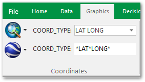
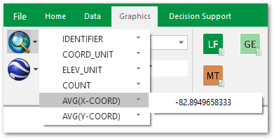
Additional fields are accessed through the drop-down to the left of the COORD_TYPE_CODE.
This view allows users to quickly access the DT_FACILITY.COORD_TYPE_CODE and DT_FACILITY.IDENTIFIER fields used to populate VW_LOCATION. The COORD_TYPE_CODE and IDENTIFIER columns define the join between the DT_FACILITY and DT_COORDINATE tables. Changes to VW_LOCATION will automatically update corresponding columns in the DT_FACILITY table and update the VW_LOCATION view.
The VW_LOCATION view enables easy viewing and access to manage the coordinate settings, which affect the output from EQuIS for ArcGIS, EnviroInsite, and other mapping software interfaces and reports that depend upon VW_LOCATION.
The X_COORD and Y_COORD values in the drop-down should be set to match the units defined for COORD_TYPE_CODE and IDENTIFIER values for X_COORD, Y_COORD, and ELEV in the DT_COORDINATE table. All depths and elevations should be in the same units for best results.
These drop-downs will be used to convert those XYZ coordinates to a desired output COORD_UNIT and ELEV_UNIT in VW_LOCATION and other VW_* views. This will normalize all XYZ coordinate values to a common unit, even when individual rows in the DT_COORDINATE, DT_LITHOLOGY, DT_WELL_SEGMENT, DT_WELL, and DT_LOCATION tables have different *_unit fields.
All the third-party interfaces that use coordinate values benefit from these settings when doing exports, including ArcGIS.
Note: Conversion factors must be present in the RT_UNIT_CONVERSION_FACTOR table for this feature to work. |