|
<< Click to Display Table of Contents >> Navigation: EQuIS Library > Reports > Standard Reports > Water Levels > Hydraulic Containment |
Report Name: Hydraulic Containment (example1) (example2) (example3:kmz)
File Name: EarthSoft.Reports.Library.126862.dll
Dependencies: EarthSoft.Reports.Library.64102.dll
Software: EQuIS Professional and EQuIS Enterprise
Source: EQuIS Professional install
Language: English
Output Type: Excel1 or Keyhole Markup Language (*.kmz)2,3,4
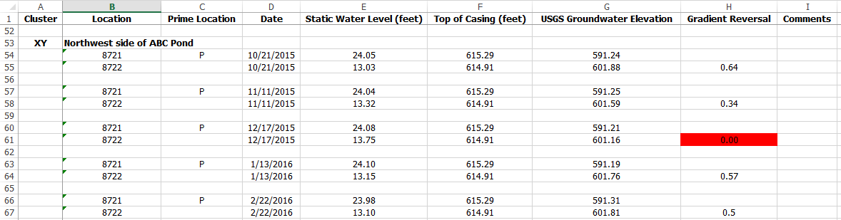
Description: This report produces a table in Excel or a map in Google Earth showing the Gradient Reversal, which is determined by comparing measured water levels in primary wells to measured water levels in secondary wells, where the water level samples are taken on the same day.
Installation Instructions: This report assembly is part of the EQuIS Professional installation. No additional installation steps are necessary. For Enterprise use, both the EarthSoft.Reports.Library.64102.dll and EarthSoft.Reports.Library.126862.dll in the Enterprise bin folder (typically at C:\Program Files\EarthSoft\Enterprise\bin).
Overview:
User reports will save the Output File Type, so a user report run in Enterprise will only download the file type selected in the Output File Type parameter. The Gradient Reversal is calculated with the logic below, where P represents the primary location and S represents the secondary. The remark input (RT_GROUP_MEMBER.REMARK) is an optional predefined adjustment value, which can be used to reduce the actual gradient reversal value. This allows for flagging gradients before they reach a minimal point of concern. If the adjustment (remark) of the comparison is not needed, do not populate RT_GROUP_MEMBER.REMARK with any non-zero numeric value. Also see the output mapping sections.
1.When P is dry and its max of DT_WELL_SEGMENT.END_DEPTH with segment_type=SCREEN is measured, Gradient Reversal = S's water level elevation – (P's Top of Casing - P's max end_depth) – remark.
2.When P is dry and its measured_depth_of_well is measured, Gradient Reversal = S's water level elevation – (P's Top of Casing - P's measured_depth_of_well) – remark.
3.Otherwise, when P is wet, Gradient Reversal = S's water level elevation – P's water level elevation – remark.
Notes: •This report requires the Water Levels II (EarthSoft.Reports.Library.64102.dll) to retrieve source data. •The remark is a predefined adjustment to the calculation as explained in number three above. •The samples of S and P locations in the equations are taken on the same day. |
By default, comparison wells are related by creating a location group of GROUP_TYPE = hydraulic_containment, with group members assigned MEMBER_TYPE = hydraulic_containment. Optionally, users may update the report to enable using the standard EQuIS location groups (publish the report and change the hydraulic_containment to SYS_LOC_CODE in the datasource of the location groups parameter).
The Primary Well is denoted by RT_GROUP_MEMBER.REPORT_ORDER =1. The secondary wells used for comparison are included in the same group with RT_GROUP_MEMBER.REPORT_ORDER <>1.
This report contains a '@sigfigs' parameter to allow configuration of the number of significant digits in the report output for the water_level column. The following columns of report output are limited to a maximum of 7 significant digits:
•reference_elev
•exact_elev
•measured_depth_of_well
•lnapl_depth
•lnapl_thickness
•lnapl_density
•water_depth
•water_level_depth
•dnapl_depth
The report converts units where possible. The target output unit is from DT_FACILITY.ELEV_UNIT, DT_WELL.DEPTH_UNIT, DT_WATER_LEVEL.DEPTH_UNIT in order (first unit populated is used). The input units are as follows.
•Static Water Level (water_level_depth) from DT_WATER_LEVEL.DEPTH_UNIT, DT_WELL.DEPTH_UNIT, DT_FACILITY.ELEV_UNIT
•Top of Casing (DT_MEASURE_DATUM.DATUM_VALUE) from DT_MEASURE_DATUM.DATUM_UNIT
•For non-TileInvert results, DT_WELL_SEGMENT.END_DEPTH from DT_WELL_SEGMENT.DEPTH_UNIT, DT_WELL.DEPTH_UNIT, DT_FACILITY.ELEV_UNIT
•For TileInvert results, tile_invert (DT_LOCATION_PARAMETER.PARAM_VALUE) from
DT_LOCATION_PARAMETER.PARAM_UNIT, DT_WATER_LEVEL.DEPTH_UNIT, DT_WELL.DEPTH_UNIT, DT_FACILITY.ELEV_UNIT in order.
The DT_MEASURE_DATUM.DATUM_UNIT for “Top of Casing” output cannot be dynamic. This is because Top of Casing is calculated from the equis.measure_datum() function, which does not have any dynamic unit conversion processing.
The RT_GROUP_MEMBER.REMARK, which is used to calculate "Gradient Reversal" (as noted above) must have the unit used by the report output, because the report does not convert remark values.
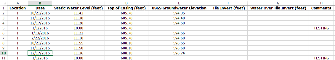
The report can generate two types of results: Non-Tile Invert Level, and Tile Invert Level (by unchecking or checking the box of the “Compare to Tile Invert Level” parameter). Their data mappings are listed in the following.
Output columns for main columns (with and without Tile Invert option) mapped to database:
1.Location = SYS_LOC_CODE
2.Date = DT_WATER_LEVEL.MEASUREMENT_DATE
3.Static Water Level = DT_WATER_LEVEL.WATER_LEVEL_DEPTH
4.Top of Casing = DT_MEASURE_DATUM.DATUM_VALUE
5.USGS Groundwater Elevation = calculated WATER_LEVEL_ELEV = WATER_LEVEL of Water Levels II
6.Comments = 'DRY' when DT_WATER_LEVEL.DRY_INDICATOR_YN=Y, otherwise = DT_WATER_LEVEL.REMARK
1.Cluster = RT_GROUP.GROUP_CODE, followed by GROUP.GROUP_DESC. Note if GROUP_DESC is not populated, the GROUP_CODE will display as DESC also.
2.Prime Location = P where RT_GROUP_MEMBER.DISPLAY_ORDER = 1 for the associated location.
3.Gradient Reversal = calculated as with the following logic, where P = primary location and S = secondary location.
When P is dry (DT_WATER_LEVEL.DRY_INDICATOR_YN=Y) and its max of DT_WELL_SEGMENT.END_DEPTH with segment_type=SCREEN is measured:
WATER_LEVEL_ELEV for S - (DT_MEASURE_DATUM.DATUM_VALUE for P - max of DT_WELL_SEGMENT.END_DEPTH for P) - RT_GROUP_MEMBER.REMARK for S
If not 1, and P is dry and its measured_depth_of_well is measured:
WATER_LEVEL_ELEV for S - (DT_MEASURE_DATUM.DATUM_VALUE for P - DT_WATER_LEVEL.measured_depth_of_well for P) - RT_GROUP_MEMBER.REMARK for S
When p is wet:
WATER_LEVEL_ELEV for S – WATER_LEVEL_ELEV for P - RT_GROUP_MEMBER.REMARK for S
The Gradient Reversal may be negative or zero.
•For KML output, it is used to draw a circle in a Google Earth Map where the radius (in linear-scaled feet) of each circle = absolute of Gradient Reversal * slope + intercept. If the value is negative, the color of a circle is red to represent poor containment. Otherwise, a positive value makes a green circle for good containment.
•For Excel output, Gradient Reversals of <=0 are highlighted with red and equal 0.
When the report produces a tabular table, there is an option to generate a Tile Invert Level Report by selecting the "Compare to Tile Invert Level" parameter.
Output mappings specific to the Tile Invert Level Report:
1.Tile Invert = DT_LOCATION_PARAMETER.PARAM_VALUE where:
DT_LOCATION_PARAMETER.PARAM_CODE = 'tile_invert' and
DT_LOCATION_PARAMETER.SYS_LOC_CODE = DT_WATER_LEVEL.SYS_LOC_CODE and
DT_LOCATION_PARAMETER.MEASUREMENT_DATE matches the closest subsequent DT_WATER_LEVEL.MEASUREMENT_DATE
2.Water Over Tile Invert = DT.WATER_LEVEL.WATER_LEVEL_ELEV - Tile Invert.
Tables: DT_WATER_LEVEL, DT_WELL, RT_ANALYTE_DETAIL, DT_LOCATION, RT_GROUP, RT_GROUP_MEMBER, VW_LOCATION, DT_WELL_SEGMENT
Report Parameters * |
||||||||||||||||||||||||||||
|---|---|---|---|---|---|---|---|---|---|---|---|---|---|---|---|---|---|---|---|---|---|---|---|---|---|---|---|---|
|
||||||||||||||||||||||||||||
* This report includes hidden parameter Label Font Size, that could affect the output of the report.
Consult an EQuIS administrator if these parameters should be visible or use different default values in a published report (a report
|
1 Excel report output requires a valid license of Microsoft Excel to view the output.
2 Using Google Earth for commercial purposes requires a commercial license from Google which must be obtained separately by the end user.
3 EQuIS Google Earth reports do not require Google Earth or Google Services to generate KML files. Charts may be generated by Google Charts.
4 KML is an open standard that may be read or viewed in other applications. These reports have only been tested in Google Earth.
Copyright © 2026 EarthSoft, Inc. • Modified: 08 Jul 2024