Report Name: Analytical and Water Results (example)
File Name: EarthSoft.Reports.Library.44408.dll
Dependencies: Analytical Results II and Water Levels II
Software: EQuIS Professional and EQuIS Enterprise
Source: EQuIS Professional install
Language: English
Output Type: Report Grid1
Description: Analytical and Water Results combines Analytical Results II and Water Levels II to report water level data as CAS_RN results. This enables direct comparison in crosstab reports. This report uses specific logic for computing the corrected water level elevation, based on input parameters selected by the user. For more information, see Water Level Report Basics and the Water Level Elevation Correction Diagram.
Installation Instructions: This report assembly is part of the EQuIS Professional installation. No additional installation steps are necessary.
For use in EQuIS Enterprise, an administrator must publish the report and its dependencies to the database in EQuIS Professional. The Analytical Results II (EarthSoft.Reports.Library.50943.dll) and Water Levels II (EarthSoft.Reports.Library.64102.dll) report DLLs must be in the Enterprise bin folder but should already be present.
Overview:
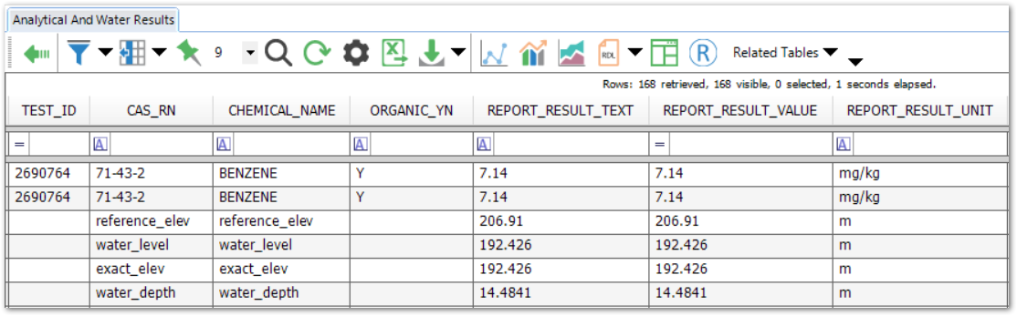
The report takes the output elements of Water Levels II (such as REFERENCE_ELEV) as new analytes, appending them to the standard Analytical Results II output, as pictured in the report excerpt below.
Report Parameters * |
|---|
Report parameters are from Analytical Results II and apply to analytical results, with the following exceptions:
Location section – report input parameters (described in Analytical Results II) for both analytical results and water levels.
Water Level and Water section – parameters from Water Levels II, plus Water Level > Include Rows with no Water Level Data (default = False, which excludes water level data rows with no values in REPORT_RESULT_VALUE)
|
* This report includes the hidden parameter Facility (default = active facility), that could affect the output of the report.
If listed, the Additional Fields parameter may be customized as explained in How To Customize the Additional Fields Parameter.
Consult an EQuIS administrator if hidden parameters should be visible or use different default values in a published report (a report that allows saving of user reports). Hidden parameters cannot be viewed or changed in unpublished reports outside of a report parameter file.
|
The data mappings from Analytical Results II columns to Water Levels II fields are:
Analytical Results II |
Water Levels II |
|---|---|
SAMPLE_DATE |
MEASUREMENT_DATE |
ANALYTICAL_METHOD |
MEASUREMENT_METHOD |
ANALYSIS_DATE |
MEASUREMENT_DATE |
REPORT_RESULT_UNIT |
DEPTH_UNIT |
CAS_RN/CHEMICAL_NAME |
The following field names: DNAPL_CAS_RN, DNAPL_DEPTH, DNAPL_THICKNESS, EXACT_ELEV, LNAPL_DENSITY, LNAPL_DEPTH, LNAPL_THICKNESS, MEASURED_DEPTH_OF_WELL, REFERENCE_ELEV, WATER_DEPTH, WATER_LEVEL |
REPORT_RESULT_VALUE |
Values for the above fields
LNAPL_CAS_RN (value must be null or numeric for report to plot; otherwise, leave DT_WATER_LEVEL.LNAPL_CAS_RN blank and instead use the Water Level\Default Specific Gravity: parameter described in here to calculate lnapl_density.) |
Input Parameters: To customize Additional Fields, see How To Customize Additional Fields Parameter.
Note: In Additional Fields for this report, DT_WELL_SEGMENT uses a default SEGMENT_TYPE of SCREEN. An administrator can change this setting in ST_CONFIG with the following entry: •CONFIG_SECTION = ar •CONFIG_KEY = SEGMENT_TYPE •STRING_VALUE = the SEGMENT_TYPE to use, e.g. CASING |
Water Level\Task(s) (param_name "@task_wl_codes") uses a SingleSelect display_type by default, but Administrators or SQL Server users with the appropriate permissions can change the input type to MultiSelect, as follows:
1.Open ST_REPORT and ST_REPORT_PARAMETER.
2.In ST_REPORT, search for the Analytical and Water Results report.
3.Copy the REPORT_ID.
4.In ST_REPORT_PARAMETER, filter REPORT_ID on that copied ID.
5.Find PARAM_NAME = @task_wl_codes.
6.Change the DISPLAY_TYPE from SingleSelect to MultiSelect to allow the selection of multiple task codes for water level data.
The "Water Level\Include Rows with no Water Level Data" parameter will include or exclude water level data rows with no values in REPORT_RESULT_VALUE. By default, the report will exclude water level data rows with no values in REPORT_RESULT_VALUE from the report output.
Tables: All of the tables used by Analytical Results II and Water Levels II Reports
1The Report Grid provides additional export options to Excel, Google Earth, Outlook, Shapefile, PDF, Text, Access, XML, or a printer.
Note: The Extra Selects parameter is applied separately to the Analytical Results II and Water Levels II datasets, which can result in errors if a selected column exists in only one dataset. As a workaround, use the Column Configuration parameter in Action Level Exceedance II with Water Levels (Grid) report instead. |