|
<< Click to Display Table of Contents >> Navigation: EQuIS Library > Reports > Standard Reports by Product > Standard with EnviroInsite > EnviroInsite Spider Diagram |
Report Name: EnviroInsite Spider Diagram (example)
File Name/stored procedure/function: EarthSoft.Reports.Library.EnviroInsite.dll
Dependencies: report, schema, licensing dependencies
Software: EnviroInsite, EQuIS Professional, EQuIS Enterprise
Source: EnviroInsite install
Language: English
Output Type: Geographic feature data stored as shapefiles (*.shp)
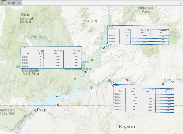
Description: The EnviroInsite Spider Diagram is used to generate location specific table data, which is then exported to a shapefile.
Installation Instructions: See the EnviroInsite Report Installation article for more detailed information.
To run in EQuIS Professional, the EarthSoft.Reports.Library.EnviroInsite.dll file should be installed to the EQuIS installation folder. A local installation of EQuIS EnviroInsite 7 is required to run the report.
Note: Using versions of EnviroInsite and Professional on the same machine that are not aligned can produce an 'evaluation' version of the report output. This occurs when using: •A version of EnviroInsite >7.23.2 and a version of Professional <7.23.2 •A version of EnviroInsite <7.23.3 and a version of Professional > 7.23.2 |
For EQuIS Enterprise, additional files must be added to the Enterprise bin folder. The required files are packaged (EnviroInsite_Enterprise_package_x64_{build #}.zip) and available on the EarthSoft Community Center Downloads dashboard (All Items\Products\EnviroInsite\v7).
Overview:
The crosstab output generates an additional row header for analytes and separates analytes into separate columns. When including header date, the output is transposed so that the columns include the dates and rows include the analytes.
The report generates data based on Constituent, Matrix, and Fraction pairs. Users should select a list of constituents, a single matrix, and a single fraction for the report to query the database and produce output.
To display shapefile data in ArcGIS Pro, the report requires projection data to be included in RT_COORD_TYPE.ESRI_SPATIAL_REF. An associated COORD_TYPE_CODE with the coordinate system and coordinate zone is also required to locate this data. If this information is missing, then there may be problems when plotting the spider diagrams.
Tables: All tables used by the Analytical Results Report and DT_WATER_LEVEL
Report Parameters |
||||||||||||||||||||||||||||||||||||||||||||||||||||||||||||||
|---|---|---|---|---|---|---|---|---|---|---|---|---|---|---|---|---|---|---|---|---|---|---|---|---|---|---|---|---|---|---|---|---|---|---|---|---|---|---|---|---|---|---|---|---|---|---|---|---|---|---|---|---|---|---|---|---|---|---|---|---|---|---|
|
Copyright © 2026 EarthSoft, Inc. • Modified: 24 Feb 2026