•New or Alternatively-named Field Parameters
•Stabilization Formulas in Field Parameters
Overview
The General Water Sampling Template offers a complete environmental data management workflow, including field data collection, chain of custody creation, submission of data to the EQuIS database for water levels, and ground or surface water sample data collection. This template is highly configurable and is not meant to be ready for immediate use, but rather a framework that can be adapted to various needs and workflows. See the Simple Modifications to Standard Collect Templates Office Hours recording for tips on modifying standard Collect templates to help configure this template.
Note: There are two versions of the General Water Sampling Template. The General Water Sampling (Build 7.22.2 and Greater) version includes the Table Form field type and Dynamic Selector field type functionality and is configured to work with Collect 7.22.2 and greater. The General Water Sampling (Build 7.20.4 and Greater) version does not include the Table Form or Dynamic Selector functionality and is configured to work with Collect 7.20.4 and greater versions. |
|---|
Both versions of the General Water Sampling template can be downloaded from the Collect Templates folder on the Downloads dashboard on the EarthSoft Community Center. Ensure the template file has been unblocked prior to uploading to a Collect Enterprise dashboard (see Unblock Downloaded Files article for more details). The template can be uploaded via the Template Designer page of Collect Enterprise.
Note: Since the General Water Sampling template is built on the EDGE format, the EDGE format must be available on the Enterprise site prior to uploading the template. |
|---|
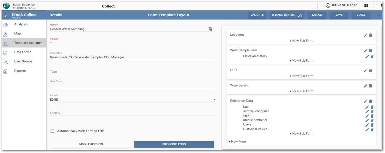
Collect Enterprise Example
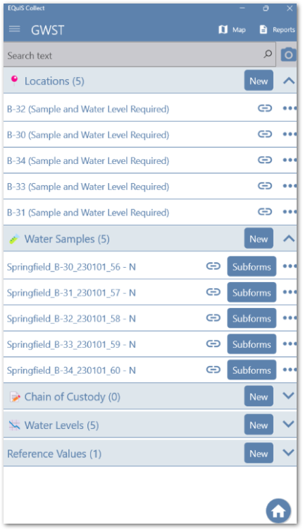
Collect Mobile Example
Pre-population
The General Water Sampling Template is pre-populated using sections of the Collect – Field EDD report listed below. The Requirements column contains information about which parameters are required to ensure the report sections appear in the report output.
Report Section |
Requirements |
|---|---|
Location_v1 |
Locations referenced selected SPM task code, or Locations manually chosen under Reference > Locations. To use only manually selected locations, ensure parameter “Only Selected Locations” is set to TRUE. |
Facility |
Report section is always exported. |
Users |
Make selection in report parameter: “User(s)”. |
Task |
Make selection in report parameter: “SPM Task Code(s)” for specific task codes. If left blank, all task codes associated to the plan code will export. |
SPM_Sample_Containers |
Selected SPM task code includes scheduled containers information. |
SPM_Samples |
Selected SPM task code includes scheduled samples information. |
Activities_all |
Selected SPM task code includes scheduled activities information. |
Water_Level |
Selected SPM task code includes scheduled water level information. |
Most_Recent Measurements |
Make selections in report parameter: “Years Back”, “Historical Range Outlier” and set “Include Most Recent Field Measurements” to TRUE. |
Additionally, the SPM FieldParameters report section is utilized in the Water Samples Form when the sample has a Contract MAG assigned and the Field Analyte Group Code equals Field. No additional parameters need to be selected for this section of the report to be output because the selected SPM task code includes the necessary field parameters. The resulting SPM_FIELDPARAMETERS.CAS_RNs are combined in a field titled "MyFieldParams" on the Water Sample form. The field parameters listed in the JOIN function will determine which parameters appear on the Field Parameters form by checking if the hard coded parameter value for each individual parameter is included in MyFieldParams. Currently, there are 33 hard coded field parameters available in this template. If the hard coded field parameter values do not match the SPM_FIELDPARAMETERS.CAS_RN values, the codes will need to be changed for the parameter’s individual fields in the template.
MyFieldParams will not pre-determine which field parameters are shown in the Field Parameters form if an ad hoc sample is created. Instead, field parameters can be selected from a multi-selector field titled "Field Parameter", located underneath "Field Results" in the Water Sample form. A list of field parameters and their associated values are listed below.
Field Parameter |
Code |
|---|---|
Water Level (m) |
DTW_FIELD |
Flow Rate/Flow Rate Unit |
FLOW_RATE |
pH (pH Unit) |
PH_FIELD |
Temperature (°C) |
TEMP_FIELD |
Electrical Conductivity (mS/cm) |
EC_FIELD |
Specific Conductance/Specific Conductance Unit |
FIELD_SC |
DO (mg/L) |
DO_FIELD |
Turbidity (NTU) |
TURBIDITY_FIELD |
ORP (mV) |
REDOX_POT |
DO (%) |
DO_FIELD_SAT |
Color |
COL_FIELD |
Free Chlorine (mg/L) |
FREECHLOR_FIELD |
Odour |
ODOUR_FIELD |
Salinity (ppt) |
SALINITY_FIELD |
Total Suspended Solids (mg/L) |
TSS_FIELD |
Transmissivity (%) |
TRANSMIS_FIELD |
Total Dissolved Solids |
TDS_FIELD |
Instant Flow reading |
FLOW_INST |
Secchi |
SECCHI |
Rolling Net Flow |
FLOW_NET |
Net Daily Flow |
FLOW_NETDAILY |
Totalizer Flow Reading |
FLOW_TOTALISER |
Purge Volume |
PURGE_VOL |
Visual Examination |
VISUAL_EXAM |
Totaliser Volume Reading |
VOLUME |
Stream Flow – Area |
LIH_SG_FlowArea |
Stream Flow – Rate |
LIH_SG_FlowRate |
Stream Flow – Maximum Depth |
LIH_SG_MaxDepth |
Potable – Taste |
TASTE |
Air Monitoring Area |
Area |
Surface Pond Depth |
DEPTH_Pond |
Total Pond Depth |
Max_Depth |
Stream Flow – Velocity |
LIH_SG_Velocity |
New or Alternatively-named Field Parameters
New or alternatively-named field parameters can also be added to the template.
Example:
Currently the pH parameter CAS_RN is hard-coded as ‘PH_FIELD’, but needs to be changed it to an alternative CAS_RN, such as ‘FIELD_PH’ to satisfy your data workflow.
In the Field Parameters subform, change the Visible attribute for the pH field (pFIELD_PH) from
OR(AND(NOT(ISEMPTY([#parent_sampleid])),IN('PH_FIELD',[#parent_myfieldParams])),AND(ISEMPTY([#parent_sampleid]),IN('PH_FIELD',[#parent_FieldParams_Adhoc])))
to
OR(AND(NOT(ISEMPTY([#parent_sampleid])),IN('FIELD_PH,[#parent_myfieldParams])),AND(ISEMPTY([#parent_sampleid]),IN(‘FIELD_PH’,[#parent_FieldParams_Adhoc])))
where FIELD_PH is the valid value for pH in your workflow.
This will ensure that the CAS_RN pre-populated into the MyFieldParam comma delimited list can be found by the parameters Visible attribute to ensure the field shows if it is a scheduled parameter measurement.
Additionally, the value hardcoded in the data mapping will also need to be changed in order map the correct CAS_RN back back to the DT_RESULT. To do so, in the FIELDPARAMETERSX data mapping, change the Variables attribute object for pH from
{
"X": "''PH_FIELD''",
"Y": "[pFIELD_PH]",
"Z": "''pH Unit''"
}
to
{
"X": "''FIELD_PH''",
"Y": "[pFIELD_PH]",
"Z": "''pH Unit''"
}
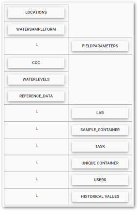
Template
The template layout is shown below.
The General Water Sampling Template was created to utilize the Collect Mobile Map feature. The Location form populates the Collect Mobile Map with all pre-populated locations if the Location_v1.geo_location field was populated in the Collect – Field EDD report. Locations can be added ad hoc by creating a new Location record with the GPS Location field populated, which uses the Geography field type. In the map view, users can see what actions are required at each location, water level reading or sample collection, as indicated by the location markers. Once a location is selected on the map, the selection of an action, under the Actions tab, will navigate the user directly to either the Water Samples or Water Levels forms.
Stabilization Formulas in Field Parameters
Parameter |
Description |
Stabilization Function(s) Used |
|---|---|---|
Specific Conductance |
For at least three consecutive records, the relative difference of two consecutive specific conductance readings remains within ± 5%. |
STABLERD |
pH |
For at least three consecutive records, the |
STABLEDIF |
Dissolved Oxygen |
For at least three consecutive records, dissolved oxygen remains below 0.5 mg/L or the relative difference of two consecutive dissolved oxygen readings remains within 10%. |
STABLELE STABLERD |
Turbidity |
For at least three consecutive records, the turbidity remains below 5 Nephelometric Turbidity Units (NTU) or the relative difference of two consecutive turbidity readings remains within ± 10%. |
STABLELE STABLERD |
Note: Each of the parameter descriptions listed above are referenced from: https://www.epa.gov/sites/default/files/2015-06/documents/Groundwater-Sampling.pdf. |
|---|
Definitions for each stabilization function listed above are provided below:
STABLEDIF – Checks that the difference between the two consecutive values is always less than the specified tolerance.
![]()
STABLELE – Checks that all values to be checked are less than or equal to the specified tolerance.
![]()
STABLERD – Checks that the relative difference between two consecutive values is always less than or equal to the specified tolerance.
![]()
Additional information, including examples, is available in the Stabilization Functions documentation.
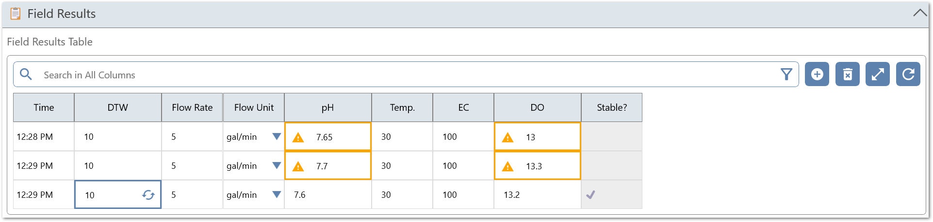
Note: In the 7.22.2+ version of the General Water Sampling template, the field parameters can be entered via the Table Form field in the WaterSampleForm. When the field parameters are viewed in the Field Parameter subform, and stabilization is reached, a check mark is appended to the GridValue. In the Table Form field, it is not possible to append additional text to any field type. Therefore, when the parameter is not stabilized, a Warning
|
|---|
Sync Functionality
The General Water Sampling Template is ready to utilize the Sync feature by default. The chart below summarizes the Unique Data Sets defined for each form in the template.
Form |
Unique Data Set (CONCAT) |
|---|---|
Locations |
Location_v1:sys_loc_code |
Water Sample Form |
[task],[sys_loc_code],[sampleType] |
COC |
[COC],[#stamp_user],[#stamp_time] |
Water Level |
[sys_loc_code] |
Reference Data |
[facility_code],[facility_name] |
Lab |
[Lab] |
Unique Container |
[container_id] |
Task |
[task_code] |
User |
[person_name] |
Historical Value |
[sys_loc_code] |
Field Parameters |
[#parent_sys_sample_code],[#stamp_time] |
sample_container |
[container_id] |
Note: The Unique Data Sets listed above might not work for every workflow. Refer to Data Sets on Collect Forms documentation for more information about defining data sets. |
|---|
Reports
The following reports are included with the General Water Sampling Template:
•Sample Info
•Form Summary
•COC
Note: A logo can be inserted in the top left corner of the local COC report by adding the desired logo, as a PNG file, to the Files directory inside the zipped folder that contains the General Water Sampling Template. |
|---|