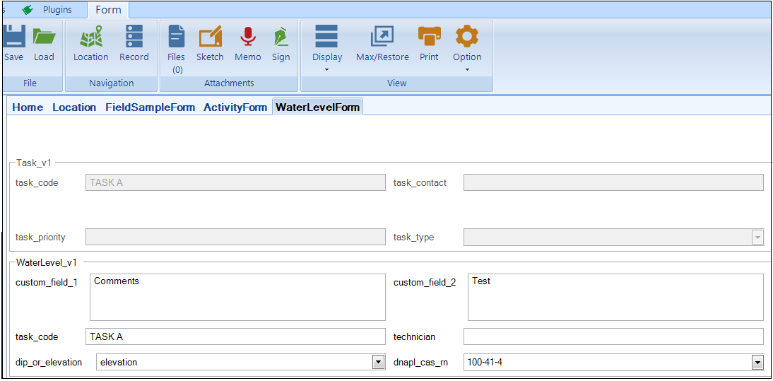
The Water Level Form (referred to in EDGE as WL Form) provides a user-configured custom form for data that would otherwise be collected in the Water Levels tab, and which populates the WaterLevel_v1 section of the EDGE EDD.
The Water Level Form may be made visible using the “Show/Hide Tabs” item on the EDGE Menu, as explained in the Data Tab Chooser.
Setup Water Level Form
Click Edit to configure which water level data fields display. A "Data Section" window will appear which gives the user the ability to show, hide, caption or rearrange the data fields.
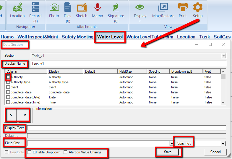
•Display Name – A user friendly name for the section.
•Check Box – Toggle to make a field visible/invisible.
•Up/down Arrows – To reorder the fields, highlight the required field and click the appropriate arrow until the desired layout is achieved.
•Display Text – User friendly name for the selected field.
•Field Size – The user may choose to adjust the font size of the form.
•Editable Drop-down – Allows user to edit drop-down menus.
•Alert on Value Change – Allows the user to receive alerts upon changing values in the selected fields.
•Save – click to save changes and return to the form.
The user may optionally add in activity sections, such as Well Inspection items, that would normally be recorded in either the Activities data tab or the EDGE Activity Form. Setup of these activity sections is identical to that of the Activity Form, more details are available in the Activity Form.
Signature Panes can be added to the form using the Sign button in the Form tab. More details are available in Attaching Signatures.
Using Water Level Form
1.Select a Task from the Task Chooser and a Location from the Location Chooser.
2.To add a new water levels record, click New.
3.Populate fields as applicable.
To create another instance of the form for the same location, click New again. Note that two instances of the form cannot exist at the same date, time, and location, as these values help differentiate record uniqueness in the WaterLevel_v1 section of the EDGE EDD.
To navigate among instances of the form at a particular Location, select Record located in the Form tab on the top of the screen.
The Water Level Form may be customized with a logo. For further information click on Form Logos.
The user may increase/decrease the size of the font by going to the options in the Form Tab, and selecting Font.
Some of the built-in format checks in the Water Level Form:
•Populate historical_reference_elev with Location_v1.RefElev.
•RetrieveLNAPLCasRn – Search groups to see if they contain the location; if they find it, then get the cas_rn from the group.
•HistoricalWaterLevelCheck – Add warning to depth to water, if outside of range.
•HistoricalLNAPLCheck – Similar to above, but for LNAPL.
•EDGE_GetWell_Info – Populate total_depth_readonly and top_of_screen_readonly from Location_v1 section.
•Populate water_level_elev by subtracting water_level_depth from historical_reference_elev.
•Adds a warning to the water level value is below the screen (Only updates on edits to water record, not if the screen is updated on the location).
•If WL Qualifier populated and WL is entered, then issue warning to reconcile data.
•Calculate LNAPL Thickness.
Depth to Water Clearing
The water_level_elev is a calculation of historical_ref_elev and depth_to_water.
1.An enumeration "water_level_elevation_clearing" determines whether or not the water_level_elev will clear upon deletion of depth_to_water.
2.If the enumeration is set to "Y", when the depth_to_water or historical_ref_elev field is cleared, the water_level_elev field is also cleared.
3.If the enumeration is set to "N", when the depth_to_water or historical_ref_elev field is cleared, the water_level_elev will not clear.
Elevation Calculation
1.EDGE will calculate the elevation differently, depending on what the waterlevel_v1.dip_or_elevation is set to.
a.If set to waterlevel_v1.dip_or_elevation = "elevation", then elevation = Ref Elevation - depth to water.
b.If set to any other value, then elevation = Ref Elevation + depth to water.
Additional Features
1.The water level general section will copy over the data in its fields when a new record is created.
a.For example, if the Technician field had "John Smith" entered and then the user creates a new record, it will still contain John Smith in the new record.
b.Some fields are populated by default as soon as the record is created, such as date, and may be different than the previous record.
2.Error Flag Refreshing – A feature was added to the Water Level Form, named Error Flag Refreshing. Entering data in a field will flag errors on other fields. The flags become visible immediately (either when changing or exiting the control) with no need to refresh the form.
3.In the WaterLevel_v1 section of the EDGE Format, if dry_indicator = NULL and water_level_depth = NULL then WaterLevel_v1 will not be mapped to dt_water_level. This allows collection of purge data without corresponding water level data.