Report Name: Geotechnical Water Content vs. Depth (example)
File Name: EarthSoft.Reports.Library.176839.dll
Dependencies: Licensed EQuIS Geotech and Geotech Schema
Software: EQuIS Professional and Enterprise
Source: EQuIS Geotech (EarthSoft Community Center > Products > EQuIS Geotech)
Language: English
Output Type: Excel1 or PDF
Description: The Geotechnical Water Content vs. Depth report plots the water content results against depth for all samples in each selected location. This report filters the results based on the selected task and will only display samples that have an associated DT_GEO_TEST.TEST_TYPE = 'Water_Content'. This report can be run in EQuIS Professional or published to EQuIS Enterprise.
Installation Instructions: This report requires an EQuIS Geotech license and the Geotech Schema applied to the database. The Geotechnical Water Content vs. Depth report (EarthSoft.Reports.Library.176839.dll) is available for download in the Products\EQuIS Geotech folder on the Downloads Dashboard on the EarthSoft Community Center. For Enterprise use, this report should be published to the database. When publishing the report, the assembly should be stored in the database. The report will be available for selection once it has been published.
Additional Details:
The data for the report are queried from DT_GEO_RESULT.GEO_RESULT_CODE = ’water_content’ and the associated DT_GEO_TEST.TEST_TYPE = 'Water_Content’.
The report supports a maximum of 10 locations to plot per chart. Each location receives its own “symbol” as a data marker. For locations with more than 2 water content results, the result values are connected by a line.
When running the report, DT_SAMPLE.TASK_CODE must be populated to generate an output.
Only the Project/Location related Shared Report Attributes apply to this report. This report supports task_code based paging.
Template:
Note: The EarthSoft_WaterContentvsDepth.xlsx template file is provided with EQuIS Geotech. See the Geotechnical Template Configuration article for detailed information on editing/creating Excel templates for use with EQuIS Geotech reports. |
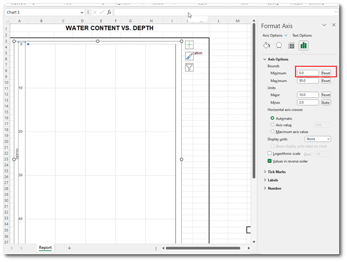
The report respects the Chart Type defined in the template. Depth should be on the Y-axis. Water Content (%) should be on the X-axis. The report supports the X/Y Max axis defined in the Excel template, unless the 'Y-Axis Max Override' is defined in the report parameter. When 'Y-Axis Max Override' is not used, the Y-axis needs to be consistent.
It is highly suggested to set the X/Y Minimum bound to 0.0 in the template.
Tables: DT_GEO_RESULT, DT_GEO_TEST, DT_LOCATION, DT_SAMPLE, DT_TASK
Report Parameters |
||||||||||||||||||
|---|---|---|---|---|---|---|---|---|---|---|---|---|---|---|---|---|---|---|
|
1Excel report output requires a valid license of Microsoft Excel to view the output.