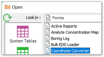
Form Name: Coordinate Converter Form
File Name: EarthSoft.Forms.Library.71938.dll
Software: EQuIS Professional
Source: EQuIS Professional install
Description: The Coordinate Converter Form, available under Forms in the Open window, allows you to convert coordinates stored in DT_COORDINATE from one COORD_TYPE to another.
Installation Instructions: The Coordinate Converter Form is part of the EQuIS Professional installation. No additional steps are necessary.
Overview:
Note: Prior to making changes with the Coordinate Converter Form, we strongly encourage users to create a database backup. Changes made by the form are permanent and irreversible alterations to records in DT_COORDINATE.
Do not use the filter within the form's data grid. It results in the error shown below when the 'Add New' or 'Replace Existing' button is clicked.
Index was outside the bounds of the array. at Infragistics.Shared.SparseArray.ValidateIndex(Int32 index) at Infragistics.Shared.SparseArray.GetItem(Int32 index, ICreateItemCallback createItemCallback) at Infragistics.Win.UltraWinGrid.RowsCollection.get_Item(Int32 index) at EarthSoft.Forms.Library._71938.CoordinateConverter.DoConversion() at EarthSoft.Forms.Library._71938.CoordinateConverter.btnDoConversion_Click(Object sender, EventArgs e) |
Note: Application Level Security (ALS) users must have Editor or Owner permissions for the facility to run and save conversions. |
Data Section
Specify the coordinate details to convert here.
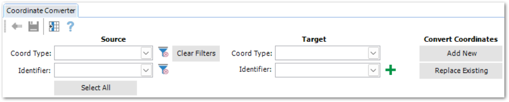
Source
Select the source Coord Type and Identifier (both required) for conversion.
•Coord Type – the drop-down lists the available coord types from RT_COORD_TYPE, where the SRID field is populated with a Well-Known ID published by ESRI. Other coord types (i.e., non-ESRI or missing valid SRID) are not supported for conversion.
•Identifier – drop-down populated from DT_COORDINATE.
These selections filter the form's grid to show records ready for conversion.
The Clear Filter ![]() buttons will remove the individual filter selections.
buttons will remove the individual filter selections.
Note: EQuIS mapping and coordinate functions rely on the RT_COORD_TYPE.SRID field to define the coordinate system used for the given COORD_TYPE_CODE. The SRID (Spatial Reference IDentifier), also know as an EPSG (referring to the European Petroleum Survey Group, publisher of the list of coordinate systems) is a universally recognized numeric code used to indicate the coordinate system being used.
If you need to find an EPSG/SRID for your coordinates, the simplest way is often to just use Google. Generally, the top results will be from one of the two following websites containing comprehensive lists of EPSG/SRID values:
For further instructions, see RT_COORD_TYPE.ESRI_SPATIAL_REF. |
Target
Select the target Coord Type and Identifier (both required).
•Coord Type – the drop-down lists the available coord types from RT_COORD_TYPE, where the SRID field is populated with a Well-Known ID published by ESRI. Other coord types (i.e., non-ESRI or missing valid SRID) are not supported for conversion.
•Identifier – drop-down populated from DT_COORDINATE. To add a new identifier for the converted result, select the Add Identifier ![]() button.
button.
Convert Coordinates
After input of the source and target details, the grid filters to the associated records.
Select rows to convert with the Select All button, or click rows in the grid to select individually.
![]()
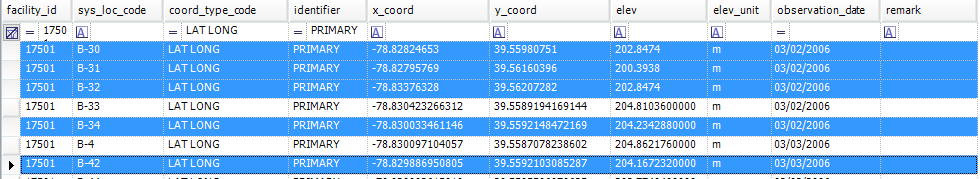
To create new records of the converted coordinates in DT_COORDINATE, click Add New. The grid will update to show the pending new records in light blue.
To replace the selected records with the converted coordinates in DT_COORDINATE, click Replace Existing. The grid will update to show the following:
•pending new records shaded in light blue
•records to be replaced shaded in red
Conversions are generated using the projection engine of ESRI's ArcGIS API for JavaScript, as documented here. Conversions can only be completed if the value of the ESRI geometry server referenced in the ST_CONFIG table is valid. By default, the ESRI geometry server chooses the best transformation based on the input data and spatial references.
For both conversion options, the form checks that no input fields are null or empty and populates these DT_COORDINATE fields for the converted records:
•OBSERVATION_DATE – populated with the current date
•REMARK – populated with the statement, "Generated by Converting Coord Type: 'COORD_TYPE_CODE' Identifier: 'identifer' to Coord Type: 'COORD_TYPE_CODE' Identifier: 'identifer'".
Note: The form does not convert elevations. |
After validation, the Back ![]() and Save
and Save ![]() buttons are available.
buttons are available.
Review the highlighted rows to ensure expected output.
Select the Back button to change inputs or selected rows.
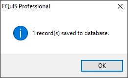
Select the Save button to complete the conversion process. This will append the converted values in new records or replace the original coordinates with the converted values in the database (for Add New or Replace Existing, respectively). A confirmation window will display how many records were saved.
Note: Any records in DT_COORDINATE added or modified by the Coordinate Converter form will have a null EBATCH value. Thus, after loading an EDD with a new location and its coordinates, then modifying those coordinates via the Coordinate Converter form, you cannot roll back the EDD, as that would leave orphan records in DT_COORDINATE.
To resolve this behavior, do either of the following before a rollback: 1.Delete modified records from DT_COORDINATE, or 2.Manually populate the EBATCH of the converted coordinates (to match the EBATCH of the original EDD) in DT_COORDINATE.EBATCH. |
After the Save process, the Coordinate Converter Form refreshes with the new data from DT_COORDINATE.