When using EQuIS for ArcGIS, a coordinate system must be defined in RT_COORD_TYPE.ESRI_SPATIAL_REF, or else the coordinate system in ArcMap will be set as "<undefined>'. For locations to render spatially with proper placement using coordinate data, the COORD_TYPE_CODE definition in the RT_COORD_TYPE table needs to include accurate ESRI_SPATIAL_REF and SRID. This field may be populated as follows:
1.Log in to EQuIS Professional and open the RT_COORD_TYPE table.
2.For the coordinate system being used, open the coordinate system projection file *.prj file, usually located in the C:\Program Files\ArcGIS\Coordinate Systems directory (or Reference Systems directory), in a text editor such as Notepad. For example, for Springfield's UTM Zone 17N NAD 27, open the NAD 1927 UTM Zone 17N.prj file.
Note: As of ArcGIS 10.1, projection files are no longer installed on the local drive. Follow the steps below to retrieve the appropriate *.PRJ file. 1.Launch ArcMap. 2.Right-click on the Data Frame title in the Table of Contents, and then click Properties. 3.Navigate to the Coordinate System tab. 4.Right-click on the desired Coordinate System in the tree, then click Save As. 5.Save the *.prj file.
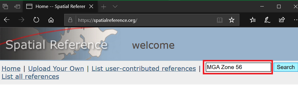
Without ArcGIS, the Spatial Reference Identifier (SRID) may be obtained as follows. The example below is for the Map Grid of Australia (MGA) Zone 56. 1.Go to https://spatialreference.org and search “MGA Zone 56”:
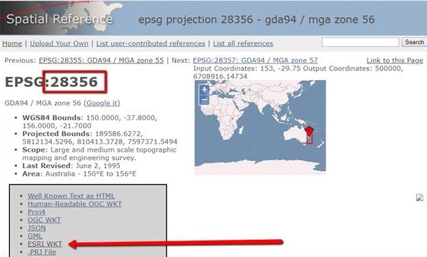
2.By clicking on the returned link, users can find the SRID, 28356. The ESRI_SPATIAL_REF (a long that must be copied exactly) can be obtained by clicking on the “ESRI WKT” link:
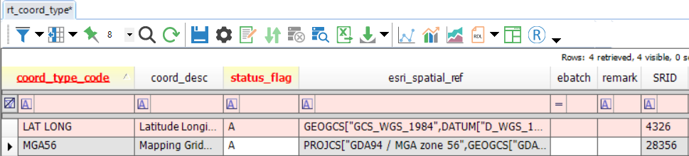
3.Copy these items and paste them in the MGA56 record in the RT_COORD_TYPE table:
|
|---|
3.Copy and paste the full EPSG string/PRJ representation of the coordinate system from the *.prj file into RT_COORD_TYPE.ESRI_SPATIAL_REF.
4.Save the changes.
To specify a vertical coordinate system as well as a horizontal coordinate system, append the contents of the vertical coordinate system *.prj file to RT_COORD_TYPE.ESRI_SPATIAL_REF. If the field contains the string VERTCS[, the vertical coordinate system will be set for users of ArcGIS 9.2 or later. For example, for NAVD 88, the following would be appended to the ESRI_SPATIAL_REF value.
VERTCS["NAVD_1988",VDATUM["North_American_Vertical_Datum_1988"],PARAMETER["Vertical_Shift",0.0],
PARAMETER["Direction",1.0],UNIT["Meter",1.0]]
Given a horizontal coordinate system of UTM Zone 17N NAD 27, the entire RT_COORD_TYPE.ESRI_SPATIAL_REF value would be the following.
PROJCS["NAD_1927_UTM_Zone_17N",GEOGCS["GCS_North_American_1927",DATUM["D_North_American_1927",
SPHEROID["Clarke_1866",6378206.4,294.9786982]],PRIMEM["Greenwich",0.0],UNIT["Degree",0.0174532925199433]],
PROJECTION["Transverse_Mercator"],PARAMETER["False_Easting",500000.0],PARAMETER["False_Northing",0.0],
PARAMETER["Central_Meridian",-81.0],PARAMETER["Scale_Factor",0.9996],PARAMETER["Latitude_Of_Origin",0.0],
UNIT["Meter",1.0]] VERTCS["NAVD_1988",VDATUM["North_American_Vertical_Datum_1988"],PARAMETER["Vertical_Shift",0.0],
PARAMETER["Direction",1.0],UNIT["Meter",1.0]]