At some sites or locations, permission may be required to perform sampling or other field events. The Land Access page in SPM Enterprise provides an easy way to view, create, or edit land access information for a specific facility. Unlike the Land Access form in SPM Desktop, multiple locations can be simultaneously assigned to a land access agreement. In addition, more detailed information for points of contact can be added or edited. The Land Access page can also be used to maintain permits and display the status of well abandonment and decommissioning.
Land access information is location specific and is displayed on a series of tabs, which are related and responsive to selection/filtering on other tabs. Detailed instructions are provided for each of the tabs in separate articles (click links below).
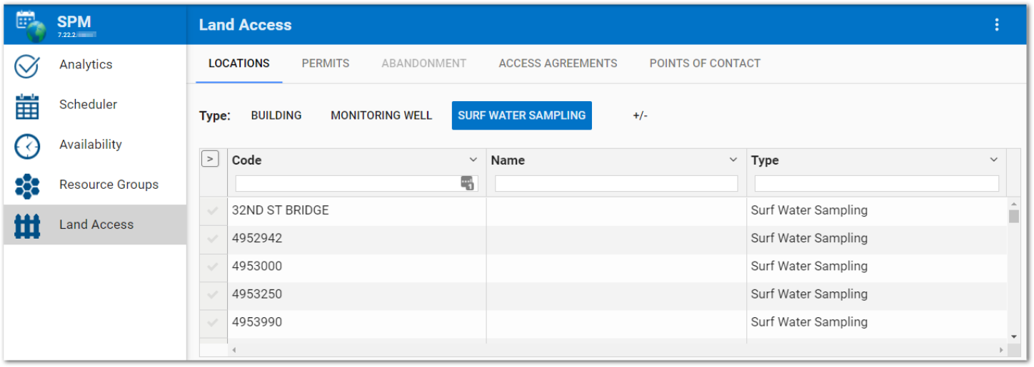
•Locations – This tab allows the user to select the desired location for the land access information, add or modify selected location information, and easily create child locations.
•Permits – Use the Permits tab to create or modify existing permits, especially when the permit type is "well" or "water use".
•Abandonment – The Abandonment tab is enabled when a location is selected and displays the status of well abandonment and decommissioning.
•Access Agreements – Use the Access Agreement tab to create or modify existing access agreements.
•Points of Contact – Land owner and/or tenant contact information can be easily entered, modified, or removed on the Points of Contact tab.
Customize Land Access Tabs
By default, the SPM Enterprise Land Access page consists of five tabs: Locations, Permits, Abandonment, Access Agreements, and Points of Contact. Administrative users can directly edit the JavaScript Object Notation (JSON) properties to permanently define:
•which tab(s) are displayed, via the landAccessTabItems, or
•what information is displayed on the tabs, using the tab settings available via the landAccessLocation, landAccessPermits, landAccessAgreement, and/or landAccessPointsOfContact.
Follow these steps to permanently modify the Land Access page settings:
1.Select the Land Access page (to load Land Access JSON properties to the JSON Editor).
2.Click the More Options ![]() icon on the right-side of the SPM widget header.
icon on the right-side of the SPM widget header.
3.Select Edit Settings.
Changes will be applied to the SPM widget by clicking the Save ![]() button. The Widget Editor will close and changes will be reflected on the Land Access page.
button. The Widget Editor will close and changes will be reflected on the Land Access page.
landAccessTabItems JSON Property
This JSON property can be used to define which tabs appear on the Land Access page. By default, this property is empty and all tabs are displayed. Any tab name(s) added to the landAccessTabItems, as string values, will be displayed on the Land Access page and tabs not listed will be hidden.
The string values for the tab names used to define the landAccessTabItems property are:
•Locations
•Permits
•Abandonment
•AccessAgreements
•PointsOfContact
Note: The Land Access Tabs will always display in the same order regardless of the order listed in the landAccessTabItems JSON property. |
|---|
landAccessTabItems Example
This example will only display Locations, Permits, and Points of Contact tabs on the Land Access Page.
{
"defaultMenuItem": "LandAccess",
"menuItems": ["ResourceGroups", "LandAccess", "Analytics"],
"landAccessLinks": [],
"landAccessTabItems": ["Permits", "PointsOfContact", "Locations"],
"landAccessLocation": {
"types": [],
"childLocationFilters": {},
"readOnly": false
},
"landAccessPermits": {
"types": []
}
}

Tab Settings
Tabs on the Land Access page can be permanently customized via tab setting JSON properties. These tab settings will be reflected each time the tab is opened. Most tab settings are not applicable across all tabs. Here is a list of the tab settings and which tabs they can be applied to:
Tab Settings |
Locations |
Permits |
Access Agreements |
Points of Contact |
|---|---|---|---|---|
types |
X |
X |
|
X |
childLocationFilters |
X |
|
|
|
fieldEditability |
X |
X |
X |
|
gridColumns |
X |
X |
X |
X |
readOnly |
X |
X |
X |
|
types – The types setting can be used in the Locations, Permits, and Points of Contact tabs. The “types” JSON property can be used to define which types appear on the specified Land Access page tab. For example, “types” on the Locations tab could be various SYS_LOC_CODE values. By default, this setting is empty. Type(s) added to the array for a specific tab will be displayed above the grid on that tab.
Types Example
In this example, DATA PROVIDER and DRILLER will display as available type filters on the Points of Contact tab:
"landAccessPointsOfContact": {
"types": ["DATA PROVIDER", "DRILLER"],
"gridColumns": ["Code", "UserId", "Name", "City", "State"],
"contactTable": "rt_company"
}
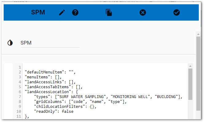
childLocationFilters – This property is only available for the Locations tab. The childLocationFilters property is used to filter child locations for location types.
childLocationFilters Example
In the example below, only locations with a type of ‘SURF WATER SAMPLING’ will display in the Child Location table when a ‘MONITORING WELL’ location is selected in the main grid view.
"landAccessLocation": {
"types": ["MONITORING WELL", "SURF WATER SAMPLING"],
"gridColumns": ["code", "name", "type"],
"childLocationFilters": {
"MONITORING WELL": "SURF WATER SAMPLING"
},
"readOnly": false
},
fieldEditability – The fieldEditability JSON array can be added to the tab settings for the Locations, Permits, and Access Agreements tabs.
A list of JSON objects can be set inside the array. Each object needs the keys "name", "when", and "editability" and their values set, as described below.
•“name” = the field name (as defined in table below).
•“when” = editing, creating, or both.
•“editability” = hidden or readOnly.
•When “editability” is set to hidden, the field will be hidden.
•When “editability” is set to readOnly, the field will be disabled.
Notes: •These settings can only be used on certain fields. If a setting is not allowed, it will be ignored. •When the tab has the readOnly JSON property set to true, all fields on that tab will be read-only regardless of the fieldEditability setting on specific fields. •Planned Land Access is only scheduled if there is a corresponding SYS_LOC_CODE in activity and/or sample. |
|---|
The following table is a list of available settings.
Field Keys |
Editing Options |
Creating Options |
|---|---|---|
Location Tab |
|
|
FacilityCode |
hidden |
None |
WellOwner |
hidden |
None |
WellInstallationDate |
hidden |
None |
QtrQtrSection |
hidden/readOnly |
None |
QtrSection |
hidden/readOnly |
None |
Section |
hidden/readOnly |
None |
Township |
hidden/readOnly |
None |
Range |
hidden/readOnly |
None |
Description |
hidden/readOnly |
None |
Comments |
hidden/readOnly |
None |
CustomField1 |
hidden/readOnly |
None |
CustomField2 |
hidden/readOnly |
None |
CustomField3 |
hidden/readOnly |
None |
CustomField4 |
hidden/readOnly |
None |
CustomField5 |
hidden/readOnly |
None |
ChildLocations |
readOnly |
None |
Permit Tab |
|
|
LocationCode |
hidden |
None |
IssuingAgency |
hidden/readOnly |
hidden/readOnly |
IssueDate |
hidden/readOnly |
hidden/readOnly |
PermitNumber |
hidden/readOnly |
None |
PermitNumberNaNv |
hidden/readOnly |
hidden/readOnly |
ExpirationDate |
hidden/readOnly |
hidden/readOnly |
ExpirationDateNaNv |
hidden/readOnly |
hidden/readOnly |
PermitNotes |
hidden/readOnly |
hidden/readOnly |
Applicant |
hidden/readOnly |
hidden/readOnly |
WellOwner |
hidden |
hidden |
WellNote |
hidden/readOnly |
hidden/readOnly |
Access Agreements Tab |
|
|
AccessAgreementId |
readOnly |
None |
StartDate |
hidden/readOnly |
hidden/readOnly |
ExpirationDate |
hidden/readOnly |
hidden/readOnly |
LandOwner |
hidden/readOnly |
hidden/readOnly |
AccessCustomField2 |
hidden/readOnly |
hidden/readOnly |
AccessCustomField3 |
hidden/readOnly |
hidden/readOnly |
AccessCustomField4 |
hidden/readOnly |
hidden/readOnly |
AccessCustomField5 |
hidden/readOnly |
hidden/readOnly |
fieldEditability Example
In this example for using the fieldEditability setting on the Permits tab, the array options are defined for LocationCode, IssueDate, WellOwner, and WellNote.
},
"landAccessPermits": {
"types": [],
"readOnly": false,
"fieldEditability": [{
"name": "LocationCode",
"when": "editing",
"editability": "readOnly"
}, {
"name": "IssueDate",
"when": "editing",
"editability": "readOnly"
}, {
"name": "WellOwner",
"when": "editing",
"editability": "readOnly"
}, {
"name": "WellNote",
"when": "editing",
"editability": "readOnly"
}]
}
}
gridColumns – As of the 7.22.1 Build, this setting is included by default for the Locations, Permits, Access Agreements, and Points of Contact tabs. This setting allows an administrator to customize the default grid columns by adding/removing a column key from the gridColumns array. The list below details the possible column keys that can be included for each tab.
•Locations:
code, customField1, customField2, customField3, customField4, customField5, description, facilityCode, facilityId, groupCode, id, mapCode, name, parentLocCode, remark1, startDate, type, wellOwner
•Permits:
Applicant, ExpDate, ExpDateNaNv, FacilityCode, FacilityId, IssueDate, IssuingAgency, LocationCode, Note, PermitNumber, PermitNumberNaNv, Type, WellNote, WellOwner
•Access Agreements:
AccessId, CustomField2, CustomField3, CustomField4, CustomField5, ExpirationDate, LandOwner, Locations, Remark, StartDate, Tenant, TotalLocations, origAccessId
•Points of Contact:
•When the RT_COMPANY table is selected as the contact table or the contact table is empty:
Address1, Address2, Address3, City, Code, ContactName, ContactPhoneNumber, CustomField1, CustomField2, CustomField3, CustomField4, CustomField5, Email, Name, OrigCode, PhoneNumber, Remark, State, Type
•When the DT_PERSON table is selected as the contact table:
Address1, Address2, Address3, AltPhoneNumber, CertificationNumber, City, CompanyCode, Country, CustomField1, CustomField2, CustomField3, CustomField4, CustomField5, Email, FaxNumber, FirstName, LastName, Name, OrigName, PhoneNumer, PostalCode, State. Title, UserId
gridColumns Example
In this example, wellOwner will display as a column in the grid on the Locations tab in addition to the default “code”, “name” and “type” columns.
"landAccessLocation": {
"types": [],
"gridColumns": ["code", "name", "type", wellOwner"],
"childLocationFilters": {},
"readOnly": false
},
readOnly – The readOnly setting can be added to the Locations, Permits, and Access Agreements tabs. This setting allows an administrator to set the information on a tab to read-only. By default, this setting is set to "false". Set the property to "true" to make all fields read-only.