The Land Access page in SPM Enterprise provides an easy way to view, create, or edit land access information for a specific facility. In addition, the abandonment/decommissioning status of wells can be denoted. The Abandonment tab becomes active when a location is selected on the Locations tab. The selected location is displayed on the Abandonment tab as well as the header for the Land Access page.
Note: The SPM Enterprise Land Access feature stores the well abandonment information in the DT_WELL and DT_LOCATION_PARAMTER tables. For the Abandonment tab to operate properly, the DT_LOCATION_PARAMETER.PARAM_CODE values of "AbandNotifDateExist", "FieldCheckDate", and "FieldCheckDateExist" must exist in the database. |
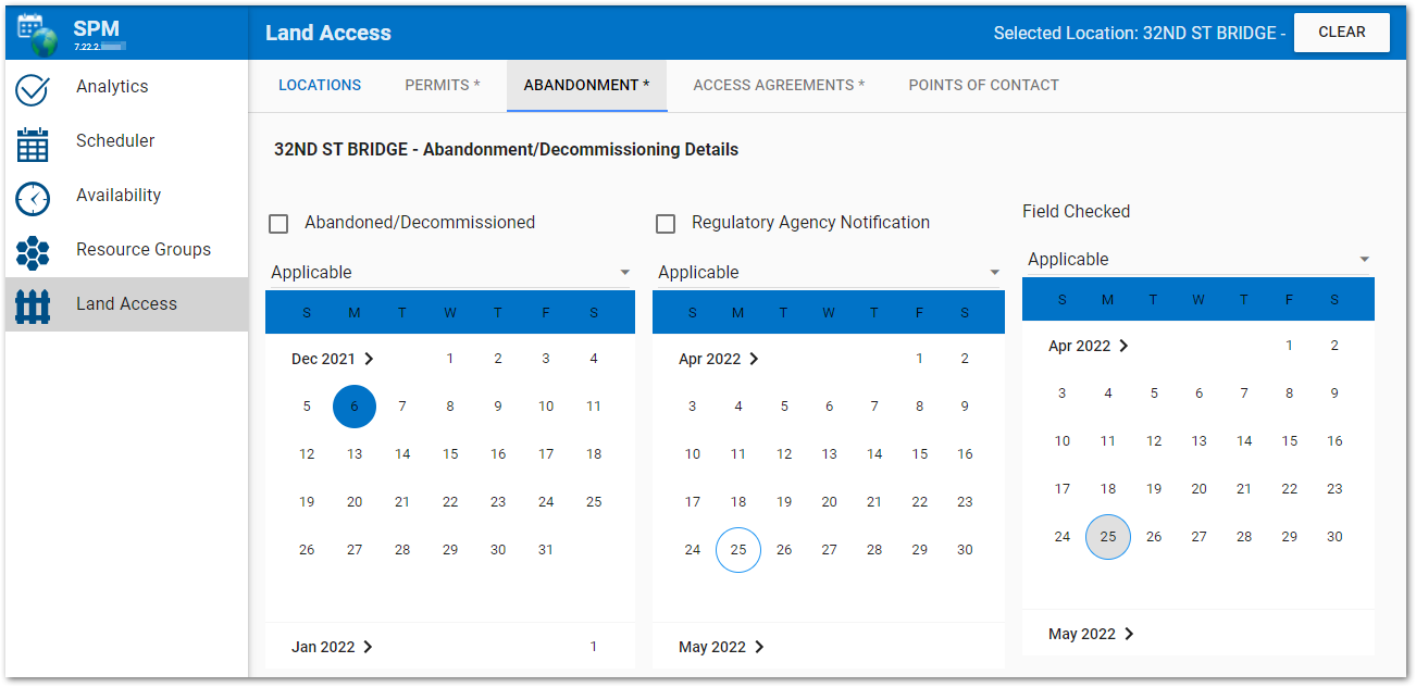
Click the Abandonment tab to view or edit the abandonment status for the selected location.
Warning: The SPM Enterprise Land Access page is directly connected to the EQuIS database. Information entered, changed, or deleted on the page will immediately be reflected in the database tables. |
The tab displays information pertaining to if/when the location was abandoned/decommissioned, if/when the abandonment has been field checked, and if/when the regulatory agency has been notified. Click the check box to indicate that the location has been abandoned and if the regulatory agency has been notified. DT_WELL.WELL_STATUS is set to "ABANDONED" when the Abandoned/Decommissioned check box is checked and is set to "Exists" when the check box is unchecked.
By default, the "Applicable" drop-down menu for each category is set to "Applicable". Click the drop-down menu for the desired category to change to either "Not Applicable" or "Not Available".
Abandoned/Decommissioned – When applicable the value is stored in DT_WELL.WELL_STATUS. Otherwise, the value is stored in DT_WELL.CUSTOM_FIELD_3, and "Not Applicable" maps to "NA" and "Not Available" maps to "NV".
Abandoned/Decommissioned Date – The value is stored in DT_WELL.CUSTOM_FIELD_1.
Regulatory Agency Notification – When applicable the value is stored in DT_WELL.CUSTOM_FIELD_4. Otherwise, the value is stored in DT_LOCATION_PARAMETER.PARAM_VALUE, and "Not Applicable" maps to "NA" and "Not Available" maps to "NV".
Regulatory Agency Notification Date – The value is stored in DT_WELL.CUSTOM_FIELD_5.
Field Checked Date – The value is stored in DT_LOCATION_PARAMETER.MEASUREMENT_DATE. Otherwise, the value is stored in DT_LOCATION_PARAMETER.PARAM_VALUE, and "Not Applicable" maps to "NA" and "Not Available" maps to "NV".
The calendar tool shows the selected date highlighted with a blue solid circle and today's date highlighted with a gray circle. If Today's date is selected in the calendar tool, it will remain highlighted with a blue circle. To select a different month or year using the calendar control, click on the name of the month or the arrow pointing forward at the top of the control. This changes the calendar tool from the month view to the year view. Once in the year view, scroll through the available years as desired. The current selected month will be highlighted with a solid circle. Select the desired month/year combo to return to the month view to pick a specific date.