To use an EQuIS database, select File> Open Database> EQuIS Database. The EQuIS Login window will open. Select the desired database. EnviroInsite will consume an EnviroInsite Decision Support license while connected to an EQuIS database. After connecting to the EQuIS database, the FormEquisSetUp dialog box will open to the Facility tab. Modify EQuIS options on the following tabs as desired:
Select OK to save changes. To make changes to EQuIS options after the initial database connection, select Edit> EQuIS Options from the main menu to open the EQuIS Options (FormEquisSetup) dialog box.
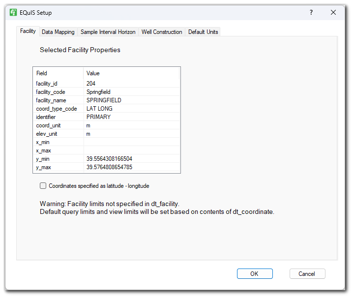
Field – Information from the DT_FACILITY table. Values in this table cannot be modified within EnviroInsite.
COORD_TYPE_CODE and IDENTIFIER – The values of COORD_TYPE_CODE and IDENTIFIER are used to determine the records queried from the DT_COORDINATE table.
COORD_UNIT – EnviroInsite reports but does not use the value of DT_FACILITY.COORD_UNIT.
ELEV_UNIT – If ELEV_UNIT is not specified, then EnviroInsite will use entered depth and elevation units with no conversion.
Facility Limits – If facility limits are not specified in the X_MIN, X_MAX, Y_MIN, and Y_MAX fields in the DT_FACILITY table, EnviroInsite will scan the DT_COORDINATE table and determine the bounds of the view from those values.
Coordinates specified as latitude-longitude – Check if coordinates are specified in the EQuIS database/facility in latitude-longitude. EnviroInsite will then convert coordinates to current specified system before plotting.
Data warnings will appear as needed.
Coordinates
EnviroInsite reads the value of DT_FACILITY.COORD_TYPE_CODE to determine which location value should be used from DT_COORDINATES. If geographic coordinates are specified as latitude and longitude and the corresponding check box is selected on the EQuIS Options dialog box, the coordinates will automatically be converted to the selected project US State Plane, OSGB36, spherical mercator or UTM.
EnviroInsite determines the coordinate system recorded in the DT_COORDINATES table based on the value in the EQuIS data fields DT_FACILITY.COORD_TYPE and the associated record in RT_COORD_TYPE.SRID.
•An SRID value of 4326 in the RT_COORD table indicates that the coordinate values are in latitude-longitude coordinates. In that case, the display coordinates will be in UTM within the UTM zone at the center of the extent of the location positions.
•SRID values starting with 326 are presumed to indicate UTM coordinates within the northern hemisphere. SRID values starting with 327 are presumed to indicate UTM coordinates within the southern hemisphere. The final two digits in either of these cases are taken to be the UTM longitudinal zone. For example, an SRID value of 32617 would represent UTM longitudinal zone 17 in the northern hemisphere. State plane coordinates are not supported at this time.
•Other SRID values for MTM, State Plane or Spherical Mercator coordinates are not presently supported.
EnviroInsite uses the same functions for evaluation of water levels as the Water Levels report in EQuIS. See the Introduction to Water Level Reports for more detailed information on Water Level reports.
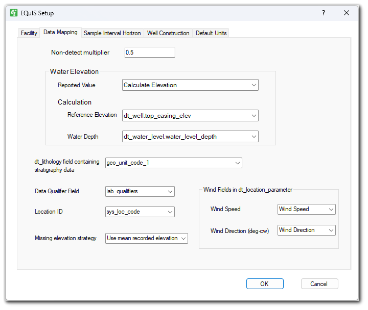
•Non-detect multiplier – The non-detect multiplier to be used in designation of values for flagged non-detect results.
•Reported Value – The water elevation value to use, DT_WATER_LEVEL.WATER_LEVEL_ELEV, DT_WATER_LEVEL.CORRECTED_ELEVATION, or Calculated Elevation using the Calculation options.
•Reference Elevation – The reference elevation to use when calculating the water elevation (reference_elevation - water_depth).
•Water Depth – The water depth to use when calculating the water elevation DT_WATER_LEVEL.WATER_LEVEL_DEPTH, DT_WATER_LEVEL.CORRECTED_DEPTH, or Calculate based on product density.
•DT_LITHOLOGY Field Containing Stratigraphy Data – The DT_LITHOLOGY field containing regional stratigraphy data, GEO_UNIT_1-5, CUSTOM_FIELD_1-5, or MATERIAL_NAME.
Note: Additional documentation about working with stratigraphy data is available at: •EnviroInsite Stratigraphy Post Values •EnviroInsite Stratigraphy Model •EnviroInsite Stratigraphy Contours •EnviroInsite 3D Stratigraphy Log •EnviroInsite Cross-Section Logs |
•Data Qualifier Field – Data qualifier field to use LAB_QUALIFIERS, VALIDATOR_QUALIFIERS, INTERPRETED_QUALIFIERS, or DQM_QUALIFIERS.
•Location ID – Location ID to use DT_LOCATION.SYS_LOC_CODE, DT_LOCATION.LOC_NAME, or DT_WELL.WELL_ID.
•Missing Elevation Strategy – Strategy for setting surface elevation when DT_COORDINATE.ELEV is not populated.
Note: Boring Logs and Subsurface Profile will always be set to "Do not plot values with NULL elevation". |
•Wind Speed – The DT_LOCATION_PARAMETER.PARAM_CODE that represents wind speed.
•Wind Direction – The DT_LOCATION_PARAMETER.PARAM_CODE that represents wind direction in degrees.
EnviroInsite needs the sample or depth interval for plotting data. Although the DT_SAMPLE table contains sample depths, for cases where repeat samples are collected from the same interval (e.g. well screens), it may not be advisable to use those values since different users may enter them with different depths. In those cases, an alternative location for the sample intervals would be a record in the DT_WELL_SEGMENT table. The option to use DT_WELL_SEGMENT for the sample interval is selected by the EnviroInsite user by indicating the DT_SAMPLE.MATRIX values that should be associated with an interval record in DT_WELL_SEGMENT.
Not all records within DT_WELL_SEGMENT will be treated as a sample interval. The value in the DT_WELL_SEGMENT.SEGMENT_TYPE field determines whether an individual DT_WELL_SEGMENT record is considered to be representative of a sample interval. The list of values for this field, which indicate that the record contains data for a sample interval, are set by the user in the Sample Interval Horizon tab of the EQuIS Options dialog box.
The IS_SCREEN_YN field of RT_WELL_SEGMENT_TYPE is used to determine the default list of SEGMENT_TYPE values considered to be a sample interval within DT_WELL_SEGMENT. Values of ‘Y’ or ‘y’ in the IS_SCREEN_YN field indicate that the associated SEGMENT_TYPE value in that record describes a sample interval or well screen. Note that EnviroInsite does not use the value of MATERIAL_TYPE_CODE in either RT_WELL_SEGMENT_TYPE or DT_WELL_SEGMENT when determining whether a SEGMENT_TYPE should be associated with a sample interval.
The figure below shows the contents of the Sample Interval Horizon tab of the EQuIS Options dialog box. In this case, DT_SAMPLE.MATRIX values of “WG” will be associated with sample intervals defined in DT_WELL_SEGMENT. All other DT_SAMPLE.MATRIX values, will be associated with sample intervals defined within DT_SAMPLE. Additionally, DT_WELL_SEGMENT records that contain SEGMENT_TYPE values of either “Screen” or “transducer” will be considered to be representative of well screen or sample interval horizons.
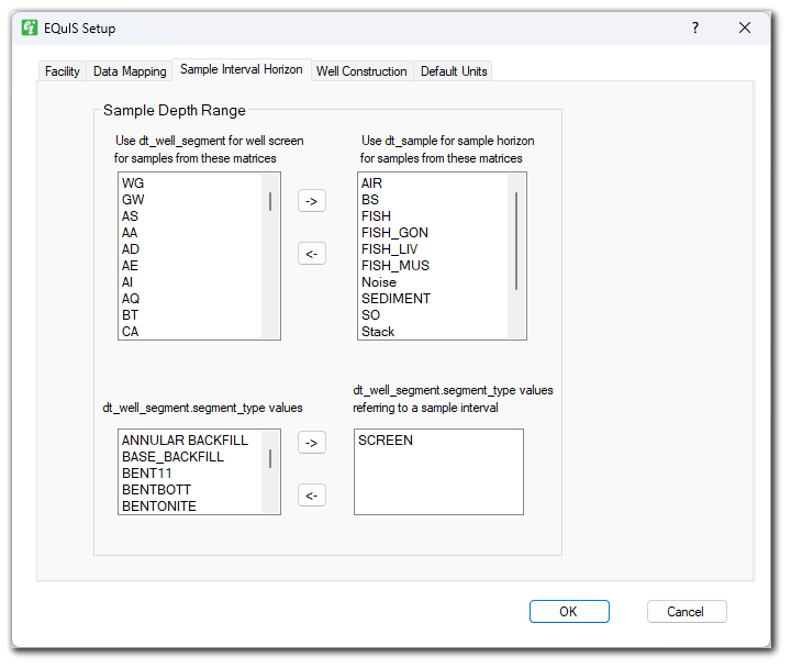
•Use DT_WELL_SEGMENT for well screen for samples from these matrices – For DT_SAMPLE.MATRIX values in this list, the sample interval will be queried from DT_WELL_SEGMENT.START_DEPTH and END_DEPTH.
•Use DT_SAMPLE for sample horizon for samples from these matrices – For DT_SAMPLE.MATRIX values in this list, the sample interval will be queried from DT_SAMPLE.START_DEPTH and END_DEPTH.
•DT_WELL_SEGMENT.SEGMENT_TYPE_VALUES referring to a sample interval – Select the DT_WELL_SEGMENT.WELL_SEGMENT_TYPE values that should indicate that a record refers to a measurement sample interval.
Click the -> and <- arrows to move matrix values between lists.
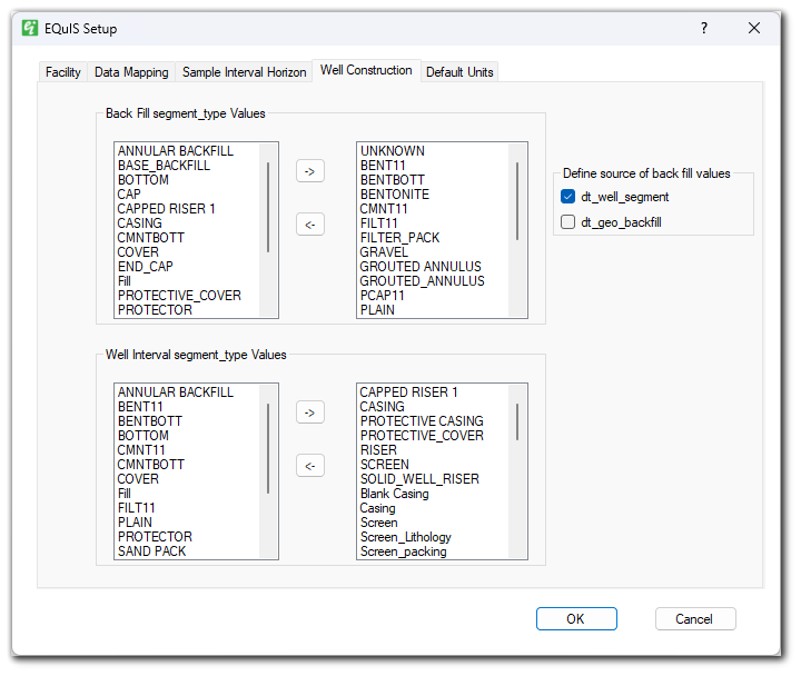
Move SEGMENT_TYPES to the rightmost lists via the right arrow (->) to select which will be interpreted as the Back Fill SEGMENT_TYPE and which will be interpreted as the Well Interval SEGMENT_TYPE for use in the Well Construction portion of Boring Logs and Subsurface Profiles. It is possible to have an entry in both the Back Fill and Well Interval lists.
Users can choose the source of the back fill SEGMENT_TYPE values from either the DT_WELL_SEGMENT table, DT_GEO_BACKFILL table or both tables by enabling the checkboxes beside each table name under the "Define source of back fill values" section. If none are enabled, the default is DT_WELL_SEGMENT. Fill materials from DT_GEO_BACKFILL will appear in the list if there is a corresponding record in DT_GEO_BACKFILL with a non-null MATERIAL_NAME value.
Note: The DT_GEO_BACKFILL option is only applicable when the Geotech Schema is applied to the database. |
The concentration units are selected from the first instance of the analyte and media matching your selection in the RT_MTH_ANL_GROUP_MEMBER table. The program will first look to REPORTING_UNITS in this table, and if not populated will use the value in DEFAULT_UNITS. These values can be set by creating analyte groups in EQuIS. If no units are found using this approach, the program will create a query that binds DT_SAMPLE, DT_RESULT, DT_TEST, and RT_ANALYTE, and selects the first instance where the chemical name and media match the values of RT_ANALYTE.CHEMICAL_NAME and DT_SAMPLE.MATRIX_CODE. If found, the program will use the value in DT_RESULT.RESULT_UNIT.
Default Concentration units can be overridden using the EQuIS options dialog box. Enter the EQuIS analyte, matrix, fraction, and concentration units desired. If the units are different from what is stored in EQuIS laboratory results tables, make sure the necessary unit conversion values are defined in EQuIS.
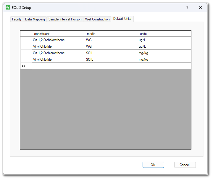
1.This table auto-populates with analytes that have already been queried for plots in EnviroInsite.
2.Units – Set the concentration units applicable to each analyte-matrix-fraction combination.