The Professional EDP DB Format tool is used to load custom EQuIS Alive formats, based on existing Survey Types, for data entry in EDP. Before the DB Format tool can be used, Survey Types first need to be created and saved using the Alive Survey Definition Form. The DB Format tool can be used to convert coordinates from one type of coordinates to another. As the DB Format tool requires an active database connection, it is only available for use in Professional EDP. The ALIVE_EDGE format is included with the Professional installation and is required to use the DB Format tool.
Using DB Format in Professional EDP
1.Open EDP on the Home tab of Professional.
2.Click on the DB Format button (located in the Open group on the Home tab).
3.Select the survey definition and click Open or Export. The format can be used to create/collect, edit, and load data for the associated Survey Type.
•Select Open to open the format directly in EDP, allowing data to be loaded and processed directly.
•Select Export to create an Alive Format File that can be used for data collection.
Converting Coordinates using DB Format
The coordinate conversion occurs during the Create step in EDP by sending the coordinates to ArcGIS to do the conversion. After Create, DT_SPATIAL_EXTENT.REMARK will show information about the original coordinates if conversion succeeded; if the conversion failed, then the REMARK field will show an error messaging to explain why.
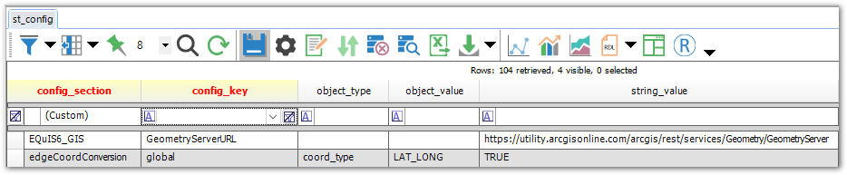
To use the coordinate conversion, the EQuIS6_GIS record needs to exist in the ST_CONFIG table along with either the edgeCoordConversion or edgeFacilityCoordConvert record. A global setting with a target coordinate type will override any facility-specific setting with the same target coordinate type.
EQuIS6_GIS
ST_CONFIG |
VALUE |
REMARK |
VALID VALUES |
|---|---|---|---|
CONFIG_SECTION |
EQuIS6_GIS |
Required |
|
CONFIG_KEY |
GeometryServerURL |
Required |
|
STRING_VALUE |
https://utility.arcgisonline.com/ArcGIS/rest/services/Geometry/GeometryServer |
Required |
edgeCoordConversion
ST_CONFIG |
VALUE |
REMARK |
VALID VALUES |
|---|---|---|---|
CONFIG_SECTION |
edgeCoordConversion |
Required |
|
CONFIG_KEY |
global |
Required |
|
OBJECT_TYPE |
coord_type |
Required |
|
OBJECT_VALUE |
<Target coordinate type from RT_COORD_TYPE.COORD_TYPE_CODE. For this record in RT_COORD_TYPE, SRID must be populated.> |
Required |
|
STRING_VALUE |
TRUE |
Required |
Remarks
This setting will apply the coordinate conversion to all facilities.
edgeFacilityCoordConvert
ST_CONFIG |
VALUE |
REMARK |
VALID VALUES |
|---|---|---|---|
CONFIG_SECTION |
edgeFacilityCoordConvert |
Required |
|
CONFIG_KEY |
<facility_id> |
Required |
|
OBJECT_TYPE |
coord_type |
Required |
|
OBJECT_VALUE |
<Target coordinate type from RT_COORD_TYPE.COORD_TYPE_CODE. For this record in RT_COORD_TYPE, SRID must be populated.> |
Required |
|
STRING_VALUE |
TRUE |
Required |
Remarks
This setting will apply the coordinate conversion to only a specific facility.
Example