Building a cross-section in EnviroInsite is easy to do. Once in the cross-section, you can select most of the same options available for plotting in plan views. When a user creates a cross-section in EnviroInsite, a Cross-Section Trace object is drawn in the plan view. See the Cross-Section Trace documentation page for instructions. Then, EnviroInsite will automatically open a new window with a cross-section plot and a key map showing the location of the cross-section on the plan view map. You can always switch between the cross-section and plan views by selecting the appropriate tab at the top of the view window. If you decide to modify the profile points, select the cross-section trace line in the plan map window and drag the points to their new locations.
By default, the bedrock surface and ground surface on cross-sections are plotted based on the contents of the Surface Elevation field in the Wells table and the deepest borehole or well. You can provide a ground surface or bedrock surface by editing the Profile plot object that is automatically created when the cross-section is generated.
View a training video on creating cross-sections in EnviroInsite here.
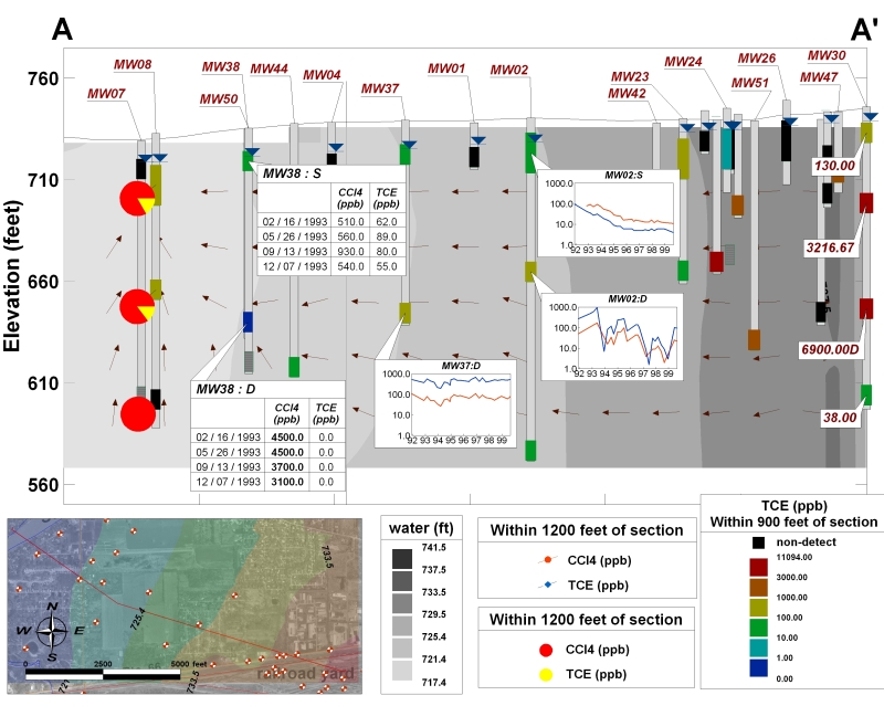
In EnviroInsite, a template file can be saved that contains the cross-section content. The template file may include contours, water levels, soil intervals, stratigraphy, data tables, time-history charts, or color-coded sample intervals.
Notes: •The cross-section vertical axes and the elevation & depth spans of object queries are defined within the template file, which makes a template file difficult to share between facilities, as those values may not be appropriate for the destination facility. They can be manually changed by editing the template file within a text editor but would likely require extensive edits. •If trying to change to share a template between multiple facilities of a database, clear the content of DT_FILE.FACILITY_ID. |
Saving a Cross-Section Template
1.Start EnviroInsite.
2.Create a cross-section following the steps in Cross-Section Trace.
3.Add the data visualization features under Plot from the main menu.
4.Save the template file by selecting View > Template > Save from the main menu.
Loading a Previously Saved Template:
1.Start EnviroInsite.
2.Create a cross-section following the steps in Cross-Section Trace.
3.Upload the template file by selecting View > Template > Load from the main menu.