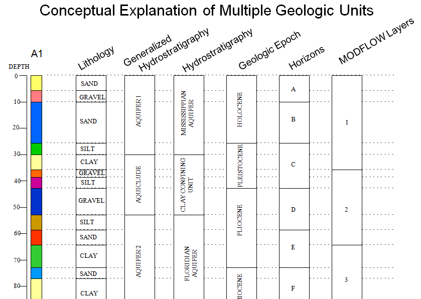
The RT_GEO_UNIT_TYPE table is the classification or category for the units in the RT_GEO_UNIT table. The RT_GEO_UNIT_TYPE table might be described as Generalized Hydrostratigraphy, Hydrostratigraphy, Geologic Epoch, Horizons, and MODFLOW Layers in the below example.
An example of Hydrostratigraphy and Soil Horizons in relevant fields of the populated RT_GEO_UNIT_TYPE, RT_GEOLOGIC_UNIT, and AT_GEO_UNIT tables are:
RT_GEO_UNIT_TYPE
GEO_UNIT_TYPE |
GEO_UNIT_TYPE_DESC |
GEO_UNIT_NUMBER |
|---|---|---|
GEOLOGICUNIT1 |
Hydrostratigraphic unit |
1 |
GEOLOGICUNIT2 |
Soil Horizons |
2 |
RT_GEOLOGIC_UNIT
GEOLOGIC_UNIT_CODE |
GEOLOGIC_UNIT_DESC |
|---|---|
MISSISSIPPIAN |
Mississippian Aquifer |
CLAY |
Clay Confining Unit |
FLORIDIAN |
Floridian Aquifer |
A |
Horizon A |
B |
Horizon B |
C |
Horizon C |
D |
Horizon D |
E |
Horizon E |
F |
Horizon F |
AT_GEO_UNIT
GEOLOGIC_UNIT_CODE |
GEO_UNIT_TYPE |
|---|---|
MISSISSIPPIAN |
GEOLOGICUNIT1 |
CLAY |
GEOLOGICUNIT1 |
FLORIDIAN |
GEOLOGICUNIT1 |
A |
GEOLOGICUNIT2 |
B |
GEOLOGICUNIT2 |
C |
GEOLOGICUNIT2 |
D |
GEOLOGICUNIT2 |
E |
GEOLOGICUNIT2 |
F |
GEOLOGICUNIT2 |
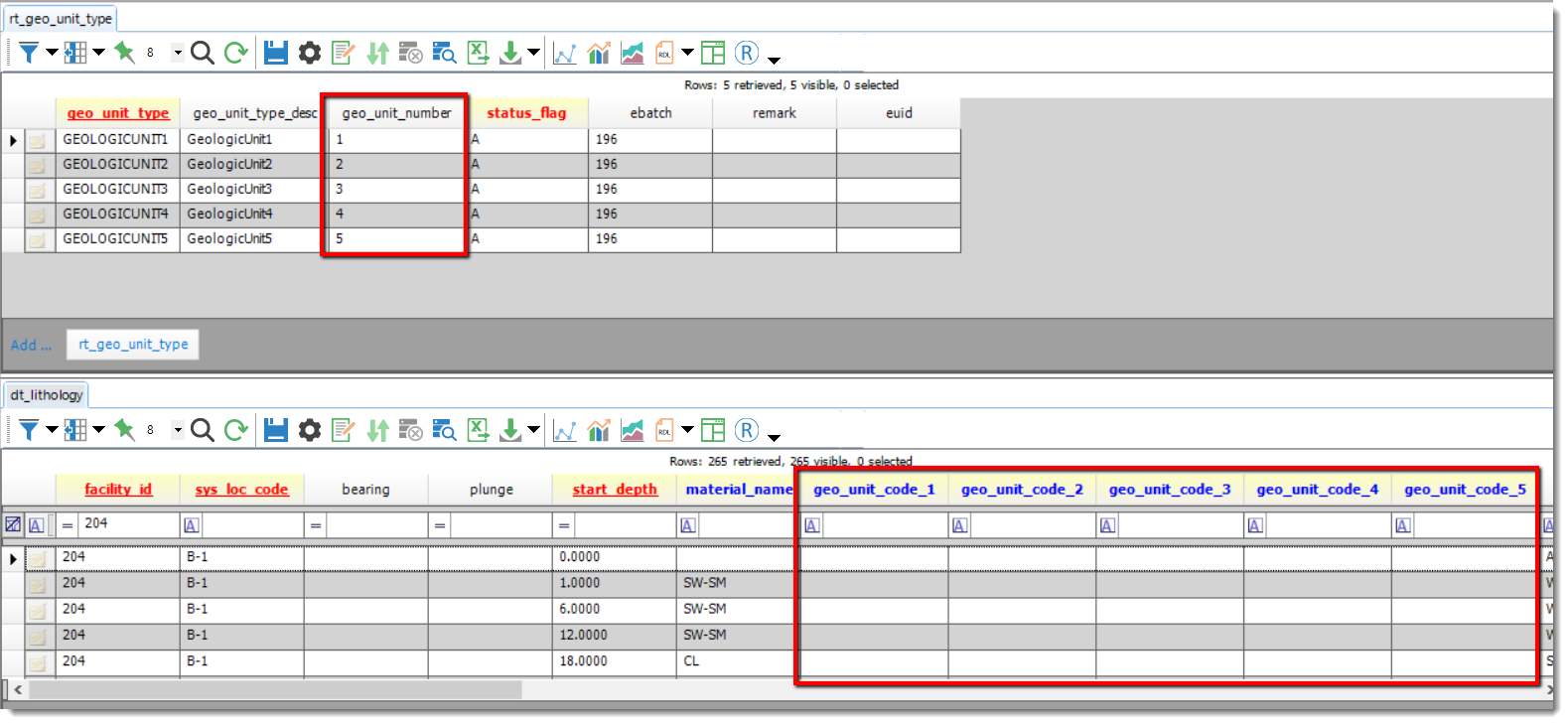
The RT_GEO_UNIT_TYPE.GEO_UNIT_NUMBER field corresponds to the GEO_UNIT_CODE_1 through _5 fields in the DT_LITHOLOGY table, as shown here:
For ease of use with third-party interfaces, renaming the RT_GEO_UNIT_TYPE.GEO_UNIT_TYPE fields (e.g., "GEOLOGICUNIT1") is not recommended. The GEO_UNIT_TYPE_DESC fields may be changed instead to add descriptions of each type as needed.
The DT_LITHOLOGY.GEO_UNIT_CODE fields are designed to store additional types of geologic data and are populated by the RT_GEOLOGIC_UNIT table. Several geology-based third-party interfaces, such as EQuIS for EVS and Rockworks make use of these additional layer types.